
From Beeston Road to Derby Road | Derby Road Underpass 1982 | Clifton Boulevard 2005 | Dunkirk Flyover | Clifton Bridge | Memories | Map
Clifton Boulevard - From Beeston Road to Derby Road
|
|
|
|
|
This photograph taken from the Fire Station tower in the early 1960s. It shows the end of Clifton Boulevard with Beeston Road going off to the left and Abbey Street just visible in the bottom right of the photograph. |
Taken in the 1950s this is the end of Clifton Boulevard with Abbey Street going off to the left. The properties behind the fence are the Barn Houses on Dunkirk Road. |
Looking south along Clifton Boulevard just before its termination at the junction with Abbey Street and Beeston Road. The photograph was probably taken in the late 1950s. |
|
|
|
|
|
This 2005 shot of Clifton Boulevard is taken slightly further back than in the previous 1950s photograph but you still get an indication of the changes which have taken place in the ensuing years. |
Taken from a microfilm copy of the Nottingham Evening Post 18 January 1938 (hence the poor quality of the image) the newspaper photograph shows work proceeding on the Dunkirk end of Clifton Boulevard. As the caption makes clear vehicles were now able to access one of the two carriageways. |
In the photograph displayed on the middle of the next row, just beyond Simms Sons & Cooke's woodyard on the eastern side of the boulevard, you can see a small recreation ground. This photograph was taken in the 1950s and shows the hard standing area and slide. See Richard Gadsby's comment's below. |
|
|
|
|
|
Clifton Boulevard as it looked in 1996. Since then the white roofed building on the right of the photograph has been demolished and a new one stands in its place (see 2005 sequence of photographs shown below) while most of the nurse homes complex just visible beyond the hospital block has also been demolished. |
A 1960s view of Clifton Boulevard taken from the University tower block. Construction work has begun on the section of Clifton Boulevard lying between Abbey Street and the River Trent. In the bottom left hand corner the petrol station shown in the next two photographs is just visible. |
Edward Snowden had just bought his first camera, an Ilford Sportsman, when he took this photograph of a Centurion tank making its way along Clifton Boulevard one weekday lunchtime in the summer of 1961. He comments that the tank tracks used to tear up the road as it turned from Beeston Road on to Clifton Boulevard and that watching a military tank pass by at close quarters was a pretty thrilling experience. |
|
|
|
|
|
This 1960s shot features the petrol station and car sales business belonging to Cripps of Nottingham. |
Another shot of the petrol station and car sales forecourt belonging to Cripps of Nottingham taken from the other end of the site. When this property was commandeered for inclusion in the QMC site Cripps opened a new petrol station and sales outlet on Lenton Lane. However it wasn't a great success and petrol sales soon ceased. Sold on to another company the site continues to house a car sales outlet. |
Also taken from a microfilm copy of the Nottingham Evening Post this time dated 25 February 1938. Lamp standards were now being erected while work was also proceeding on the laying out of cycle paths alongside it. The gap in the central reservation on the right probably provided vehicular access to Spring Close. |
|
|
|
|
|
The car in this 1960s photograph is emerging on to Clifton Boulevard from Spring Close. The building in the background is the factory belonging to Martin Emprex who can now be found operating in Sutton-in-Ashfield. |
This photograph taken in 1937 shows an early stage in the construction of Clifton Boulevard. Behind the cameraman would have been Derby Road while off in the far distance you can see some of the properties that make up Dunkirk. See Lenton Times No.9 |
A photograph taken from the University tower block this time looking towards the junction with Derby Road. The sheer number of accidents at this junction finally forced the planners to come up with the current underpass as a means of making it safer and improving traffic flow. |


|
|
|
|
|
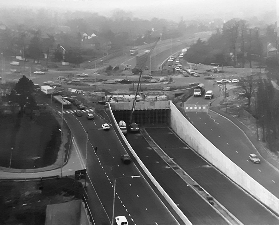
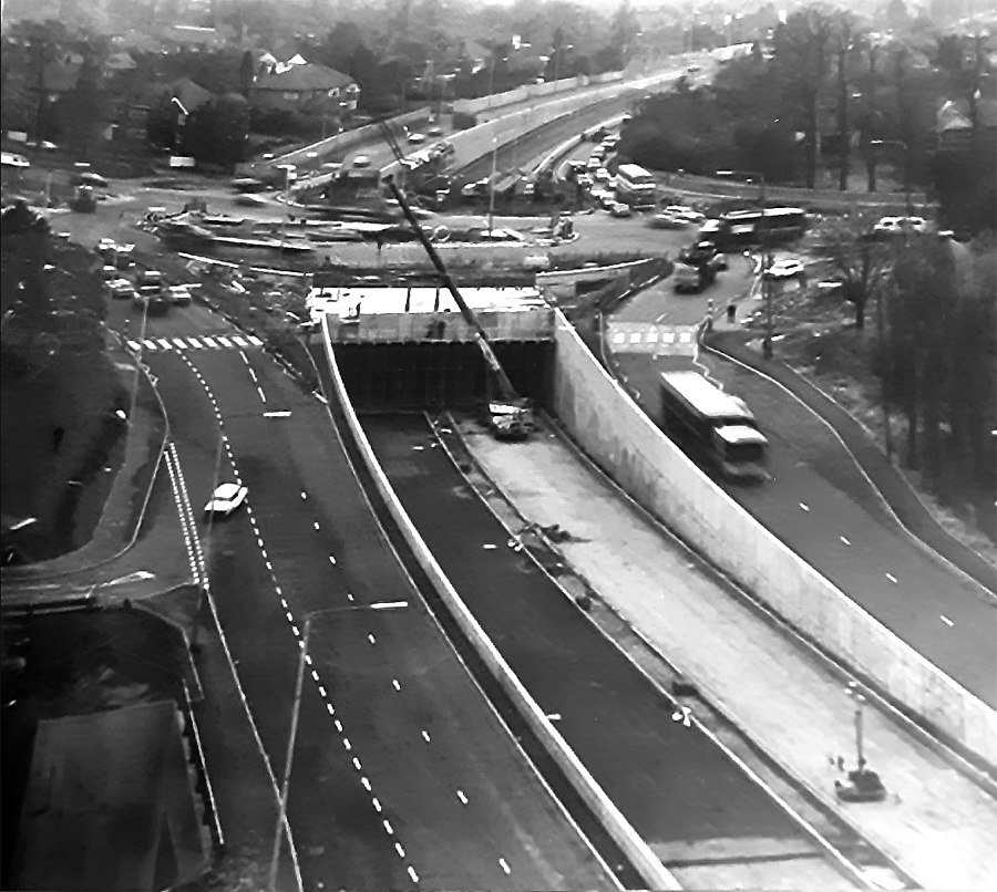
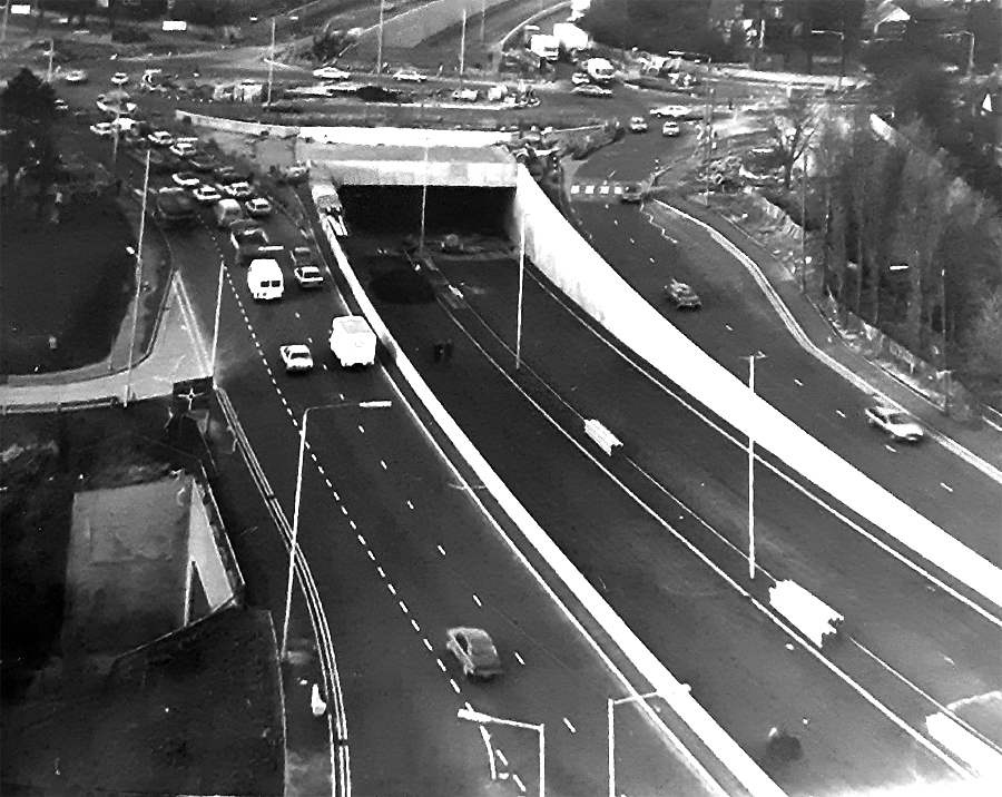
Taken from the University's tower block sometime in 1982 this photograph shows work well under way on the construction of the underpass which allows traffic to by-pass the junction with Derby Road. In this particular photograph there is still scaffolding present in the entrance to the underpass |
In this second photograph the scaffolding has been removed but work has yet to begin on excavating the rest of the underpass beneath Derby Road. |
In this third photograph the construction of the section of road which will accommodate the traffic travelling along Derby Road on its southern side is nearing completion. Once it had been finished excavation work could begin in earnest on this side of the underpass. We don't actually know who took these three photographs. If anyone can tell us the name of the photographer we would be more than happy to acknowledge it here. |
|
|
|
|
|
Looking towards Clifton Boulevard from the Derby Road roundabout with the University tower block seen in the middle distance. |
Traffic on the slip road leading up to the Derby Road roundabout with the QMC dominating the immediate skyline. |
A close-up of the pedestrian footbridge which links the Medical School with the rest of the University campus. |
|
|
|
|
|
The tower block, originally built in the late 1950s to house the Engineering Department, as viewed from ground level in 2005. |
Campus buildings old and new. On the right is part of the Coates Building while beyond it lies a more recent arrival - the Centre for Biomolecular Science. |
The Centre for Biomolecular Science viewed from its southern end with the Medical School footbridge appearing on the right of the photograph. |
|
|
|
|
|
Another of the recent additions to this part of the campus is this new building which houses the Institute of Pharmaceutical Sciences. |
The Institute of Pharmaceutical Sciences building viewed from slightly further along the Boulevard. |


Focusing on the Dunkirk Flyover
Construction of the original flyover - 1968/9
|
|
|
|
|
|
|
|
|
|
|
|
|
|
|
|


The coloured images all come from a set of slides originally taken by one of the teachers at Dunkirk School. In the ensuing years the colour on the slides has deteriorated. Although we have used computer enhancement to try and restore the original colours this has not been completely successful. The last two photographs are of slightly more recent vintage. The penultimate photograph, courtesy of Graham Woodward, shows a portion of the flyover as it looked in 1980. You can see Graham's Nottingham pictures on Flickr at www.flickr.com/photos/gwoodward/. The final photograph in the sequence taken by Paul Bexon in September 1986 shows the old flyover as viewed from the tower of Dunkirk Fire Station.
Construction of the replacement flyover - 1989
|
|
|
|
|
|
|
|
|
|
|


This sequence of photographs shows work on the replacement flyover taking place in 1989. The support pillars for the eastern side of the new flyover have all been constructed and the initial set of concrete beams are already in place. The night-time shots show one of the beams being swung into place on the first section of the flyover to straddle the road island. At this stage the original flyover is still in situ in the rear of the photographs. Once the eastern side of the new flyover had been completed two-way traffic was redirected on to the new section which allowed the construction team to demolish the old flyover and erect the western section in its place.
|
|
|
|
|
A view of the one of the support pillars under construction for the new Clifton Bridge on the city side of the river Trent. Photograph taken by Jack Hall on Sunday 14 October 1956. |
Evidently Jack Hall did not go alone to the river bank as it appears to be Jack who is posing for his photograph with the same pillar as in the previous photograph evident in the background. |
This shot, taken the same day as the other two photographs, shows the state of play with the bridge work on the Wilford side of the river. |


 The picture of the tank going along Clifton Boulevard was one of the photographs I took when I got my first camera in 1961 - an Ilford Sportsman. I took this photo one weekday lunchtime in the summer of 1961. The Simms Sons and Cook timber yard lies just behind the line of poplar trees. I wonder whether anyone remembers the mild Bob Vickerstaff in his brown warehouse coat, and his strong wife who ran the little sweet and tobacconist shop between where this photo was taken and Beeston Road. I first heard the word 'bobbydazzler' from him; he used to pepper his conversation with the word! There used to be a big black Packard car parked behind the fence further along.
I seem to recall quite often seeing a lovely dark blue French Facel-Vega car passing to and from the Boulevard and Spring Close as the driver used to make his way into and out of the Martin Emprex factory. The registration was AVM 1 (or perhaps AVM 6), so I guess that it belonged to the factory owner. Sometimes, on my way back to work after lunch I used to call in at a tiny shop on Spring Close which sold sweets and knitting wools etc. A tinkly doorbell used to ring as you walked in and it was always very dark and quiet inside, with usually a solitary customer sitting silently by the counter, not looking up. I would feel like an intruder in my big black PVC jacket and motorcycle helmet. Nothing un-necessary was said.
Moving away from Clifton Boulevard I remember that one lunchtime a friend and I walked down the cinder track from the corner of Boots factory site across to a small hump-back bridge over the Beeston Cut just on the outskirts of Lenton and Dunkirk. We looked over into the water and there was a pair of false teeth smiling up at us through the water. We fished them out of the water and took them back to the factory and had a lot of fun putting them in people's lockers. They were probably lost by someone who had over-indulged the night before and really we should have left them on the bridge parapet for subsequent collection. That cinder track was an excellent short cut for Boots' cyclists from the factory site into Nottingham. One or two people used to go home along it on their bicycles with bits of firewood tied to the cross-bar of their bikes and cycle normally with one foot but use just the tip of the shoe on the pedal with the other foot. This is rather unstable arrangement and one man had his shoe slip off the pedal resulting in a wild swerve and going into the slimy ditch. He came out black and shiny, like The Creature from the Black Lagoon.
You have certainly done Clifton Boulevard proud with all your photographs of it at various stages of construction. Although I now live in Norfolk and have lived in East Anglia since 1966 I have strong memories of it and as recently as 2005 took photographs of it for a lecture I was giving on Trees ; more of that later because my contact with the boulevard started from the time I was born which coincided with the construction of the first stretch of road. I was born in 1936 on Beeston Road and then almost immediately taken to live on Highfield Road which I did for the next twenty years. Although the road had only just been completed it had always been there from my young point of view although my parents had told me about Sandy Lane that was there before.
Highfield Road used to lead directly onto the boulevard and I used to walk along it every day to school which was on Montpelier Road. Its modern design did not mean anything to a youngster; it was ground breaking of course with its dual carriageway, cycle track, landscaping and concrete construction. We used to like the dedicated cycle track and the shrubberies in the middle were an ideal playground. No worry about traffic as there was so little. We used to watch the convoys of military vehicles go along it during the war. Some residents of Highfield Road put Clifton Boulevard in their addresses. Just after the war the 53 bus service started going along the Ring Road to Arnold. It used to park outside a friend s house on the Boulevard Maurice Webb. Fairly frequently we would go for a joy ride on the 53 bus all the way to Mansfield Road and return sitting on the upstairs front seats. I sometimes used to walk up the boulevard to catch the trolley bus operating from Wollaton Park. It was both a nice walk along an attractive road and a more interesting journey into Nottingham on the silent trackless as we called the trolleybus. The boulevard ended at the junction with Abbey Street with the PDSA on the corner. The PDSA was in converted farm buildings with a large pear tree on the roadside. The boulevard beyond to Clifton was a much later addition. You could go along the route that it was to take to go to the Trent side. First of all from Abbey Street one wound around narrow streets under the railway and over the canal past allotment gardens and then out into what we called Trent Lane [later renamed Lenton Lane]. There was another Trent Lane in Nottingham officially so called but ours was Trent Lane to us. It was like a country lane with hedges either side and wide verges. We used to go down there blackberrying. To get to Clifton and beyond you had to go around Trent Bridge if in a car or as I did when I took a summer holiday job on a farm at Barton in Fabis I went by bike down Trent Lane past the transformer for the power station behind high railings, along the river bank past the power station itself and then Clifton Colliery to Wilford Toll Bridge where you had to pay a penny to cross but at the early morning time that I crossed no one was on duty so it was free.
I mention below in a companion piece my connection when working for the City Parks Department with the Children s Playground which was built after the war. Later in my career after I had become professionally qualified and worked at Woodthorpe Grange Parks Office I was involved in designing and supervising the landscaping of the new section of the road from Dunkirk to Edwalton (this work was done in the period 1961-66) and over the new bridge, hence my earlier reference to trees. Some of the planting near the new Dunkirk School has been changed due to later developments but the rest is still in place - so you see I am still interested in the Boulevard and how it is developing!

With reference to this photograph which also appears at the top of the page: The building included in the far distance on the right of the photograph appears to be Nazareth House (you can just see the wing facing on to Abbey Street) although part of it is obscured by the garage also situated on Abbey Street. Soon after the playground was first opened it became my job (in 1953-54) to unlock the access gate while I worked at University Park; something I did first thing in the morning before going on to the park. There was a stream which I think must have run down the north side of Highfield Road between the house gardens and what is now the University which had been already been culverted along this stretch but once it passed under Clifton Boulevard it came out into the open in the vicinity of the playground and then flowed past the PDSA and went under Abbey Street. At the spot where it passed by the rear of the PDSA in early times my friends and I would have occasion to peer into the water in search of leeches. I never did know the name of this stream!
Let us know your past and present memories of Clifton Boulevard
Do you have any historical information or other photographs of this area? If so, email us with the details or write to us.