
Canning Circus | Canning Circus to Barrack Lane - North Side | Canning Circus to Barrack Lane - South Side | Barrack Lane to the Railway Bridge - South Side | Barrack Lane to the Railway Bridge - North Side | Railway Bridge to Middleton Boulevard - North Side | Railway Bridge to Clifton Boulevard - South Side | From the Boulevards to Woodside Road and Wollaton Vale
Photographs | Memories | Lenton Listener Articles | Map
|
|
|
|
|
Most of the traffic heading into Nottingham along Alfreton Road, Ilkeston Road or Derby Road will have to pass through Canning Circus exiting either via Talbot Street or Wollaton Street. The road layout within Canning Circus is now a highly complex one-way system controlled by an equally complex system of traffic lights. This aerial view taken in 1989 shows more or less the current layout with the section of Derby Road on the right-hand side of the photograph. |
This is a somewhat earlier 'aerial' view of Canning Circus taken about 1870. Part of the alms-houses that make up Canning Terrace and the entrance to the General Cemetery are visible on the left. Beyond them lies Wollaton Street and its junction with Talbot Street while the section of Derby Road can be seen on the right. At the time this photograph was taken this whole area was known as Zion Hill (or Sion Hill) it only became Canning Circus in the early 1930s. |
By the time this shot of Canning Circus had been taken in 1890 the properties at the junction of Derby Road and Wollaton Street had all been replaced by the building we know today. Over the ensuing years various businesses would be housed on the ground floor of this building. In more recent decades it used to be where Ben Bowers restaurant used to be. |
|
|
|
|
|
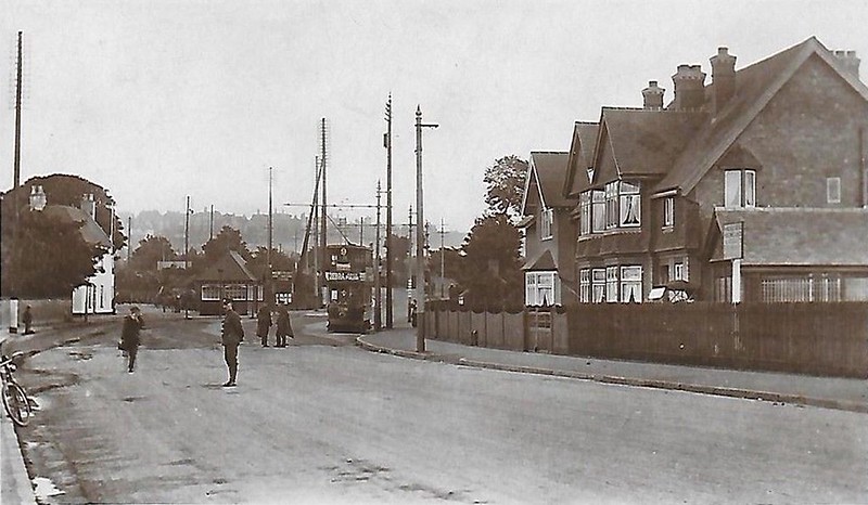
This photograph is taken from a picture postcard published in the early twentieth century. It features one of Nottingham's electric trams making its way up Derby Road. This particular tram would then have headed off along Alfreton Road. The structure to the left of the photograph was a small night shelter erected in the late nineteenth century for the use of hansom cab drivers. |
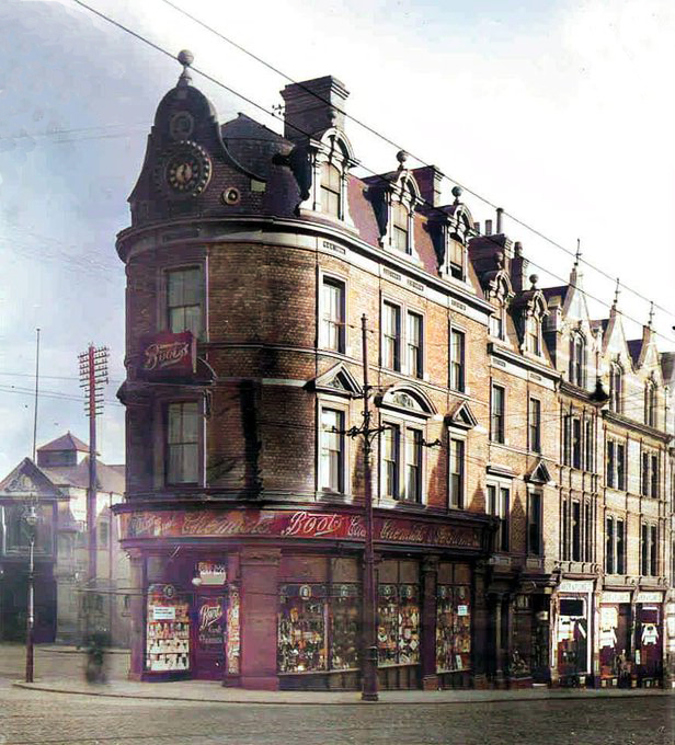
This undated picture postcard reveals Boots the Chemist to be the current occupants of 126-128 Derby Road. The property dates from the late 1870s - having been designed by Richard Charles Sutton, a well-known local architect. Robert Henry Bentley, chemist and wine merchant, occupied the shop premises in the immediate years prior to Boots' arrival in about 1910. The shop remained part of the Boots' empire until the early 1960s. |
Taken in 1935 from the flat roof of the building then occupied by Clowers funeral business we can see that the policeman on point duty has his work cut out trying to control the traffic passing through Canning Circus from six different directions. The traffic roundabout seen in the following photograph would soon be constructed and remove the need for any police presence at this point. |
|
|
|
|
|
Given the caption on this picture postcard there is no doubting where we are - there is, however, slightly more uncertainty as to when it was taken. The complex of wires suspended from the various poles provided the motive power for the trolley buses. Given the last trolleybus disappeared from the streets of Nottingham in 1966 it can't have been later than this and more likely than not, given the vintage of the cars visible in the photograph, it dates from the 1950s. |
The fact that one simple traffic roundabout (with no sign of any traffic lights) was considered quite sufficient to regulate the traffic moving through Canning Circus is the striking fact to be taken from this 1950s photograph. Beyond the roundabout are the Sir John Borlase Warren and Falcon public houses and lying between them the start of Ilkeston Road. |
This photograph was taken by Rick Wilde after the latest modification to the road layout at Canning Circus had been completed in August 1983. Also featured prominently in this photograph are the Canning Terrace alms-houses with the entrance to the General Cemetery incorporated into their design. The choice of the name 'Canning' commemorates George Canning, a Tory politician, who had become prime minister of the United Kingdom when he died in office in August 1827. |


Canning Circus to Barrack Lane - North side of the road
|
In most of the local directories published in the second half of the nineteenth century and even some of the early twentieth century editions the properties on the northern side of Derby Road stretching from the Sir Borlase Warren public house as far as Arundel Street were referred to as being on 'Park Side.' |
||
|
|
|
|
|
This photograph taken in 2015 focuses on the junction of The Ropewalk (off to the left) and the section of the Derby Road heading out to Lenton. In the 1970-80s the Georgian or early Victorian property seen here housed part of the City police force based at Canning Circus as well as the smaller, more modern building erected next door to it. |
The same prominent building featuring in our first shot is seen here on the left of this 1956 photograph taken by Rick Wilde. All the buildings seen on the other side of Derby Road as far as Elliott Street would subsequently be demolished in 1959. This was to done to create a much-widened St Helens Street, which now funnelled all traffic from Derby Road heading for Ilkeston Road or Alfreton Road and on into the one-way system we have today. The building just to the right of Alton's cigar factory is where Elliott Street would meet Derby Road. |
The stretch of cobbled street just visible the other side of the wooden barrier, is what is left of Elliott Street. Photograph taken in February 2021. |
|
|
|
|
|
Another 2021 view of Elliott Street viewed from Derby Road. City Lettings UK Ltd., the business occupying this corner property, eschews any reference to Elliott Street in its address preferring to state its location as 154 Canning Circus Derby Road, Nottingham. |
This photograph, probably taken in the 1990s, focuses on the same block of properties as in the previous photograph. In 1897 Edmund Alton & Co. moved their cigar making operation from premises in Peveril Street, Radford into this building on Derby Road. At that time it was known as the Sion Hill Factory and had previously housed various lace operations. At its peak in the first half of the twentieth century E. Alton & Co. employed about 130 people and with advent of greater automation in the 1960s was producing 1.5 million cigars a year. The cigar business closed in 1990s and the property has since been converted into apartments. The steps visible on the left of the photograph lead up to a stretch of road called Park Hill |
Those steps leading up to Park Hill are also visible on the right of this 2021 photograph. The steps now provide access to the properties fronting on to Derby Road but originally there would have led to a network of small streets, terraced properties and businesses. These have long since gone and now that area has been given over to the large apartment blocks just visible in the rear of this photograph. |
|
|
|
|
|
At the end of the block of properties shown in the previous photograph is Hermon Street - shown to better effect in this shot, taken in 2006. Hermon Street now provides access to a set of apartment blocks built by the Leicester Housing Association on part of the site of the old Drill Hall. As can be seen in the this photo the apartment block constructed on the Park Hill site stretches as far as Herman Street. |
This is the front of the old Drill Hall, which was built in 1910 to a design by the Nottingham architectural practice of Arthur Brewill and Basil Baily. It replaced an earlier drill hall, which had stood along side the walls of Nottingham Castle on Castle Road. The new building served as the headquarters and training base for a number of local territorial forces including the 7th (Robin Hood) Bn. Sherwood Foresters. After the territorial army's relocation to Chilwell the building was used as postal sorting office before being acquired by the Leicester Housing Association in 1985. The rear of the building was demolished to make way for the apartments previously mentioned, while the front portion of the building was retained and converted into offices on the ground floor with more apartments created above them. |
This 1975 photograph, taken by Rick Wilde shows the Drill Hall at the time it would have been used by the Post Office. As Rick was looking back towards Canning Circus we can just see the junction with St Helens Street with a dark coloured car waiting at the traffic lights.
|
|
|
|
|
|
This property, No.182 Derby Road, is located next to the old Drill Hall which is just visible to the right of the photograph. It is almost certainly quite a lot older than the Drill Hall - it not exactly wheelchair-friendly or suitable accommodation for any one with a pram. |
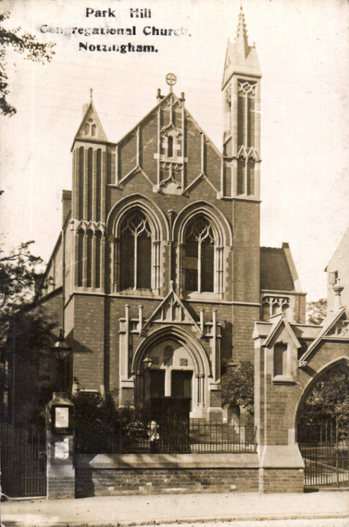
The lettering on this picture postcard may have faded somewhat but it is still easy enough to make out 'Park Hill Congregational Church, Nottingham.' Outgrowing their previous premises on St James Street, Nottingham this congregation moved to their new church on Derby Road in June 1883 with new Sunday School buildings added in 1890. Originally a Congregational church it became part of the United Reformed Church in 1972 before finally closing in 1979 |
This is No.184 Derby Road as it looks today. No longer the Park Hill Congregational Church it now houses the Greek Orthodox Church of the Virgin Mary Eleousa. The exterior of the building is more or less the same but quite a lot has been changed in its interior as the next two photographs make clear. |
|
|
|
|
|
This is the northern end of the church, which includes a painting of the Virgin Mary and the Christ Child. |
The south end of the church - the upper gallery and adjacent walls now decorated with icons with special significance to the Greek Orthodox Church. |
Just further along Derby Road from the Greek Orthodox Church is this narrow roadway known as Wellington Square. This road forms eastern boundary of Lenton Parish on the northern side of Derby Road. This current boundary extends as far as Ilkeston Road and then runs down the centre of Ilkeston Road as far as Albert Grove. It then runs half way up Albert Grove and becomes a 'virtual' boundary as it cuts across Derby Grove and Kimbolton Avenue and subsequently comes down the middle of Ashburnham Avenue to its junction with Lenton Boulevard. |
|
|
|
|
|
Looking back along Derby Road with the junction with Arundel Street off to the left. This set of properties, known as Brunel Terrace, was probably built in the 1850s. Elevated above the road level it meant that excavations could be carried out and coach houses constructed at ground level. Later as was evident in this 1980s photograph they were subsequently adapted for parking cars in them.
|
Looking back along Derby Road in 2021 we get a glimpse of what has been happening to those former coach houses in recent years. After some major modifications had been carried out two small food outlets are now in situ. We currently [2021] have 'Toast Café & Deli' while just beyond it is 'One More' - a Chinese Takeaway. |
This large building located at the corner of Arundel Street and Derby Road was built in the mid-1930s. No.206 Derby Road provided new offices and laboratories for the River Trent Catchment Board. Established in 1931 this body underwent a change of title in 1951 becoming the Trent River Board. A further change of name occurred in 1965 when it became the Trent River Authority. After Parliament passed its Water Act was in 1973 Trent River Authority was amalgamated the Severn River Authority to form the Severn Trent Water Authority and in due course the Derby Road premises were no longer required. For a number of years the building housed the Nottingham Probation Service but after they moved elsewhere the property remained empty for a number of years. The building has since undergone redevelopment and is now 'Juniper Court Apartments' - provided 'corporate serviced accommodation.' |


Canning Circus to Barrack Lane - South side of the road
|
|
|
|
|
After the number of police officers based at Canning Circus was much reduced, the building at the corner of The Ropewalk was vacated and the remaining officers and ancillary staff were confined to this concrete edifice. In April 2016 the Canning Circus police station was closed altogether and the building put up for sale. This photograph was taken in 2021 - whether it now had any new occupants is not all that clear. |
On the opposite side of Derby Road, just next to the former police station is Newcastle Terrace, one of the ways into The Park Estate. There were always a set of gates at the bottom of this stretch of road but a recent edition is this new gate at the Derby Road end |
Nos. 119-125 have stood on Derby Road for the best part of two hundred years. This photograph taken in 2017 reveals them to be in need of a little loving care and attention. In 2021 the builders were hard at work of the exterior of No.119 but the tree growing out of the joint-chimney stack of Nos. 123-25 still needed to be removed. |
|
|
|
|
|
In 2021 this sign could be still be found mounted on the front of No.123 Derby Road. However, a quick search of the internet suggests that this particular congregation now held its services at Rise Park Community Centre suggesting that the Derby Road building was currently awaiting a fresh occupant. |
This block of properties on Derby Road seen here in 2021 are known as Clinton Terrace. The two-storey extension on the right is clearly a modern addition but the darker brickwork of the more distant portion would seem to suggest that that this part of the terrace has undergone a rebuilding process. |
Moving a little further along Derby Road we get to Derby Terrace. This early picture postcard shows how it originally looked. Those who know the building will be aware that the eastern end of the terrace was demolished and a much more modern structure erected in its place. |
|
|
|
|
|
This is the building that replaced the eastern end of Derby Terrace as it now looks in 2021. When it was first constructed it came with quite a completely different facade. Designed as an office block known as The Octagon part of it became the Nottingham base of the Open University. For its second incarnation the building has now been converted into a stylish apartment complex known as 'The Park Octagon' with its main access on Western Terrace. |
This photograph provides the street view of Clinton Terrace, The Park Octagon, and part of Derby Terrace as they looked in 2021. The absence of any traffic on the road because the shot was taken during the second Covid lock-down. |
A present day [2021] view of Derby Terrace. Built as family homes in the nineteenth century the following century saw most of these properties converted into offices. No doubt with the current trend in office usage they may well be converted back into upmarket apartments.
|
|
|
|
|
|
While 'Hanbury Financial Planning' may serve as a more traditional example for the road level portions of Derby Terrace, the presence of 'The Black Door Barbers' would be appear to be a sign of changing times. |
Another shot of Derby Terrace as it looked in the early part of the twentieth century. The horse and cart and the driver are just passing the North Road entrance to The Park. |
This early picture postcard offers us a close-up of the North Road entrance to The Park. One thing that has definitely changed is the Royal Mail post box. It has since been moved further down Derby Road just beyond its junction with Barrack Lane. |
|
|
|
|
|
The equivalent shot of the North Road entrance as it looks in 2021. |
Our penultimate shot in this sequence was also taken more or less by the North Road entrance to The Park in 1962 . However the photographer was a transport enthusiast which explains why a Nottingham Corporation trolley bus is to be seen centre stage. |
Looking back along Derby Road with the Park Octagon and the Derby Terrace off to the left - while on the right lying beyond the high brick wall at No.2 North Road, The Park is the Walton Hotel, Bar and Restaurant. |


Barrack Lane to the Railway Bridge - South side of the road
|
In local directories published from the mid-nineteenth century and into the early twentieth century the location 'Lenton Sands' can be found. Initially it seems to have been used to identify properties within Lenton parish, which actually fronted on to Derby Road - stretching from just below Barrack Lane out as far as Gregory Street. Once the land either side of Derby Road was laid out for housing 'Lenton Sands' would also be attached as the location of these new side streets. Given that now it lacks any precision for the most part we will try and refrain from using the term. |
||
|
|
|
|
|
This is the junction of Barrack Lane with Derby Road. As the name implies this additional thoroughfare into The Park Estate once led to the Nottingham Barracks. These were built in Nottingham Park in the 1790s. In 1855 the lease on the building ran out; a brief extension was permitted but after the 11th Hussars left in May 1860 the buildings remained unoccupied. Most of the buildings were subsequently demolished and the properties at the southern end of Pelham Crescent erected in their place.
|
Tim Philips was prompted to take this particular photograph in 1988. While Wellington Square forms part of the north eastern parish boundary on the other side of Derby Road, on this side of Derby Road it is Barrack Lane. After passing along the southern end of Cavendish Crescent it then abuts the edge of the Park Estate. So the properties on the south side of Barrack Lane and Cavendish Crescent are actually part of Lenton. |
The photograph taken in the 1920s focuses on the properties situated on the triangular patch of land at the junction of Barrack Lane and Derby Road. It was featured in Lenton Times Issue No.9 to accompany something discovered in the Nottingham Journal newspaper in 1833, which appears to be the original sale of the land. It read:
|
|
|
|
|
|
A 1982 shot of taking in both Barrack Lane and Derby Road. At the time the photograph was taken the corner property housed a business called 'Park Batteries.' |
As is all too evident in our 2021 photograph the corner property, No.189 Derby Road, is now an outlet for purchasing fireworks. Given the recent history of the property, however, it shouldn't be too long before something else takes over. Tim Philips's photograph taken in 1988 shows 'Atom Video' which would later morph into 'Park Video.' By 2012 the premises housed 'Property Lettings' aimed at the student market. That had departed by 2014 and the property remained empty until 2017 when 'E-Liquid Paradise' moved in. Perhaps the proprietors didn't find it quite the paradise they had been hoping for as the following year saw it replaced with the current fireworks outlet. |
The occupants of this row of shops tend to change on a fairly regular basis. The one exception is The Park Stores housed in No.161 Derby Road. Since the current occupants took over in the late 1980s they have continued to expand the range and quality of the food on offer. In 2019 the Nottingham Post ran a feature on this little business suggesting that their 'corner shop' was 'possibly the best in the world.' Why not check out the Park Stores facebook page! |
|
|
|
|
|
This is what No.161 Derby Road, now known as 'Park Stores; Grocers & Delicatessen' looked like in the late 1980s. |
One of Giltbrook's dry-cleaning outlets used be based here but after the company closed this particular outlet in about 2010 a florist business called 'Art of Flowers' moved in. This is how No.165 Derby Road looked in early 2021. |
Best-One Convenience Store and Off-Licence currently occupies No.167 Derby Road. The earlier units in this row of shops and those that follow were all created by utilising the front rooms on the ground floor of existing houses. As this photograph clearly shows this was not the case for Nos.165 and 167 Derby Road. They were created in the space between two sets of properties set back from the road. Their construction took place in the late 1940s when the adjoining shop units off to the right were also created. The collection of photographs which makes up Picture Nottingham includes two images taken in 1949 showing these properties under construction. Click here to see the first of these. |
|
|
|
|
|
Nos.171 & 173 Derby Road are the remaining ground floor sales outlets which were initially created back in the late 1940s. Click here to see Picture Nottingham's other 1949 photograph of them under construction. This five-storey pair of semidetached properties had earlier been known as 'Rock Villas' and were primarily accessed as they are today from Barrack Lane. |
A 1960s shot with the two Rock Villas properties clearly looking as if they could do with a fresh lick of paint but yet again the photographer only has eyes for the No.45 trolleybus making its way up Derby Road and a second one in the distance on its way down the hill. |
In the centre of this 2015 photograph is Rocky Mount. Built in 1905-6, this property was constructed by William Thomas Norris, a Lenton-based builder, as his new family home. The property was provided with quite a large garden lying behind the two garages, although most of it consisted of quite a sleep slope. By now the house was unoccupied and the sign above the garage doors makes it clear that Rocky Mount had recently been acquired for redevelopment. |
|
|
|
|
|
Taken in April 2016 the house and garden and both garages have been demolished. Much of the sandstone rock on which the house previously stood has already been removed and soon afterwards the remaining sandstone the right of the photograph would also be extracted and taken away |
The new buildings that have since been erected in this space are shown in our 2021 photograph. With their main entrance on Barrack Lane, Park Edge consists of sixteen luxury apartments, a mix of two and three bedrooms which were priced from £217000 to £435,000. They were initially made available to buy in July 2018. |
In 1758 Parliamentary approval was granted to turn the main road between Nottingham and Derby into a turnpike. A trust was set up which set tolls for all who chose to use the road and spent the proceeds on improving and maintaining the road surface. It remained a turnpike until the expiration of the relevant Act in November 1870. This photograph shows the New Lenton turnpike gate with accommodation for the toll collector seen on the left. This shot was probably taken just before the Act expired as the tollhouse was demolished almost as soon as the Act had lapsed. The lamp standards were subsequently recycled and were placed on the posts at the North Road entrance to The Park Estate. |
|
|
|
|
|
The most likely location of the New Lenton toll house and gate seen in the previous photograph would have been at this point on Derby Road - off to the right is the junction with Harlaxton Drive. |
The traffic lights seen centre stage in the previous photograph are now relegated to the middle distance in this shot. So the junction with Harlaxton Drive is off to the right while on the left is the junction with Derby Grove. The properties now to be found on Harlaxton, Harrington and Rolleston Drives occupy an area of land that used to be the Allenfield Gardens or Gregory Gardens. As the name suggests these consisted a great many garden allotments, some of them with summerhouses, greenhouses, and in some instances semi-permanent residences. Notice to quit was served on the garden holders in various stages: initially in the early 1900s at the Derby Road end of Harlaxton Drive; then just before the Great War most of the remaining plots with the remainder disappearing once the war was over; whereupon the whole area was sold off for housing. |
This is a 2020 photograph of the junction of Rolleston Drive and Derby Road. The main entrance to the Allenfield Garden allotments mentioned in the previous text was courtesy of a trackway which ran across the allotments from Derby Road to Park Road. The line it followed was almost exactly the same as that now taken by Rolleston Drive. As to its name it was sometimes called 'Milnes' Lane' and at other times 'Mill's Lane' along with several other variants lying somewhere between the two names. In the nineteenth century in order to try and avoid paying the toll for using the Derby Road some drivers of carriages and carts would go along Barrack Lane and access the allotment complex from there, travel down them as far as Milnes' Lane and then re-emerge on to Derby Road. We know about such brazen activities from reports in the local papers where the turnpike keeper had taken to court those accused of trying to avoid payment. |
|
|
|
|
|
This 2021 photographs shows the Welby Avenue junction with Derby Road. The properties either side of Welby Avenue would also have been erected on part of the Allenfield Gardens. The property on the corner is one of Lenton's more recent religious buildings. No.215 Derby Road houses the Abu Bakr As-Siddiq Mosque. There is a slightly more imposing building in Saudi Arabia bearing the same name as this property on Derby Road which is actually one of the oldest mosques to be found in the holy city of Medina. |
Much has changed since this photograph was taken in 2006. The petrol station that once could be found just down the hill from Welby Avenue at No.221 Derby Road has already closed and the structure has been stripped down to its basic metalwork and awaits redevelopment. Behind it lies the Council's housing complex made up some five huge tower blocks erected in the 1960s, which was generally known as the Willoughby Street flats. |
The same view as in the previous photograph but taken in 2017. The tree and the bus shelter look much the same as they did in 2009 as does the right hand side of the photograph. Instead of the petrol station we now a new building occupied on the ground floor by a 'Sainsbury's Local' outlet - very popular with the student population - along with a set of flats on the first and second storeys of the building. As for the tower blocks they have now gone - never to return! |
|
|
|
|
|
Until the early 1960s, at the point where this particular thoroughfare meets Derby Road, we would have been calling it Willoughby Street and that street would have run right through to Castle Boulevard. In the 1960s redevelopment of the Willoughby Street area and the construction of the tower blocks meant only the section of Willoughby Street from Church Street to Castle Boulevard was retained. Instead, the section of road meeting up with Derby Road was renamed Park Street which then carried on round the eastern edge of the tower block complex and joined up with Church Street. Following the construction of the latest low-rise new housing complex which has now replaced the tower blocks it is still Park Street that meets up with Derby Road but now it carries straight on and follows much the same line as the old Willoughby Street. The section of Park Street that went round the side of the tower block complex is still there but has now been renamed Kyte Street. We hope that helps! |
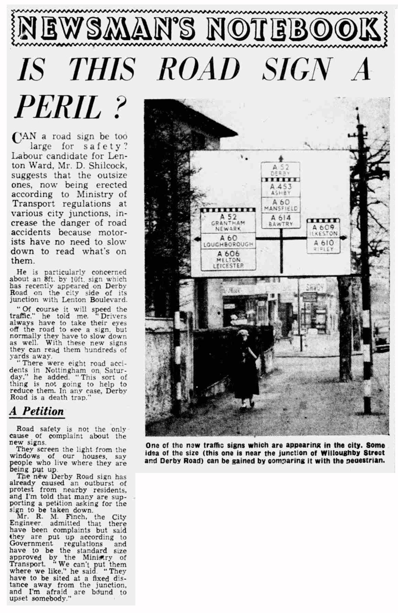
This image was taken from a local newspaper in 1957. The lightbox offers the reader not only a much larger image of the photograph but also the accompanying article which focussed on the huge size of the road sign. |
This is the building that stood at the corner of the junction shown in the previous photograph. Billy Hill's newsagency, stationers, and tobacconists, occupied No.227 Derby Road and as explained in the previous caption the property was at the corner of 'Willoughby Street.' The extension to the front of the building probably happened sometime during the interwar years. William Hill and his wife Helen, were definitely in residence there at the time of the 1939 National Survey when William was gainfully employed as a newsagent |
|
|
|
|
|
Nos.227-229 Derby Road in the days when the building was known as Willoughby Cottage and prior to the property's conversion into shops. We have no date for this photograph but looking at young boy's clothes we are probably talking before the Great War. |
Looking down the main road we have No.227, No.229 and No.231 Derby Road followed by the Savoy Cinema. The photograph is likely to have been taken in 1960 as the film poster outside the cinema appears to be advertising the film 'Circus of Horrors' which was not released in England until April 1960. |
In this 1949 shot only a tiny portion of Billy Hill's news agency is visible on the left of the photograph but we are provided with a much better view of 'Anne' - a ladies' hairdresser who occupied No.229 Derby Road, and F.J. Squire at No.231 Derby who operated as a confectioner. The film playing at the Savoy was 'Night Song' starring Dana Andrews and Merle Oberon. To the right of the cinema was Fred Richardson's Parkside Garage and Car Showroom |
|
|
|
|
|
The two shops housing Billy Hill's and Anne's businesses remained in operation in the early 1960s while work proceeded on the tower blocks behind them. This remained the case until the new Church Square shopping precinct had been erected. Whereupon it was a case of move there (which Billy Hill did) or move elsewhere (which Anne may well have done). These properties were then demolished and their location remained an open space alongside the cinema. |
The Savoy Cinema temporarily closed because of the Covid-lockdown in early 2021. The open space next to the cinema now has some quite mature trees growing on it. |
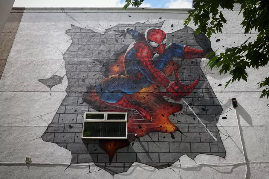
In 2024 a blank wall on the side of the Savoy Cinema gained this bold action shot of Spiderman. The mural was commissioned by the cinema and was designed by Graffwerk, a local art team. This photograph, taken by Joseph Raynor, first appeared in the Nottingham Post on 12 July 2024. |
|
|
|
|
|
A photograph of the Savoy Cinema taken by Rick Wilde in June 1995 with moviegoers eagerly queuing to get in on National Cinema Day when participating cinemas charged just £1 entry. This same photograph featured on the front cover of Lenton Times No.18 which contained a number of articles about the Savoy Cinema. |
At the time of Alan Silvers' death in February 2021 we were in the midst the of Covid lockdown so the Savoy Cinema was closed to the public which meant there was plenty of space on the display boards for the cinema to mark Alan's passing. The Nottingham Post subsequently included this photograph along with several others featuring members of the Silvers family who all worked at the Savoy. |
A 2021 shot looking back up Derby Road taking in the 'Sainsbury's Local' outlet, the Savoy Cinema and the Barclays Bank building which took the place of Fred Richardson's Parkside Garage in 1967. The bank had previously occupied the premises at the corner of Lenton Boulevard and Church Street. |
|
|
|
|
|
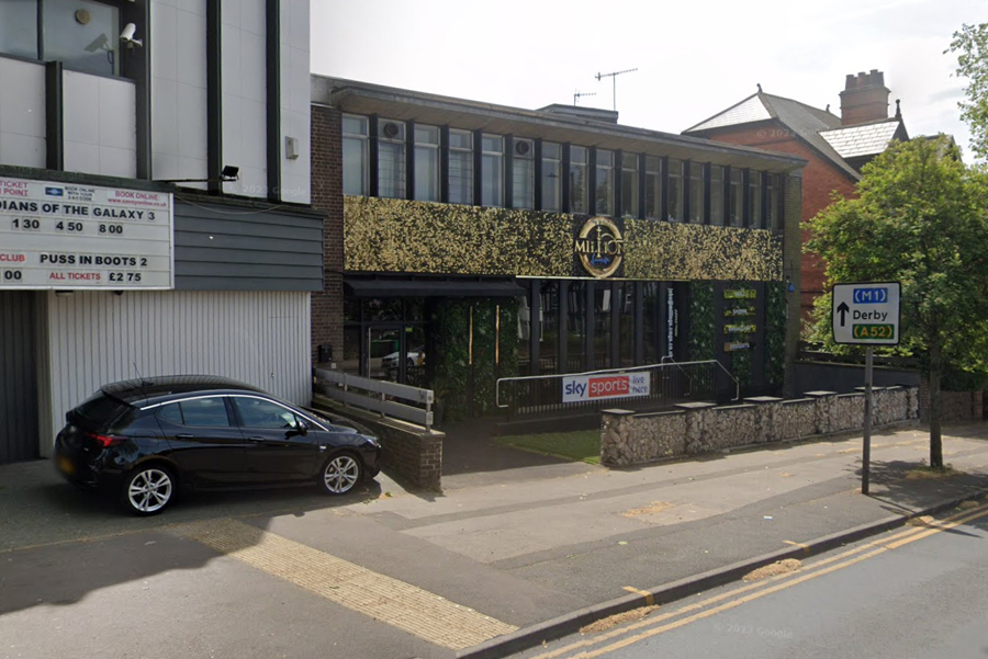
A planning application to turn the former Barclays Bank premises into a restaurant was submitted to the Nottingham City Council in 2021. The building had been empty since 2013. Despite some local opposition to the proposal the project was given the green light. The Million Lounge opened in late 2021. Our photograph was taken in 2023. Since then the restaurant has closed and in February 2025 a branch of Jimmy's Killer Prawns is expected to open. |
At the junction with Lenton Boulevard is this property No. 243 Derby Road. An imposing building that was designed by the Lenton architect, Frederick Ball, and built in 1899-1900 as the new home for Arthur Orgill and his wife, Emma Ann. Orgill had a drapery business with a number of outlets on Ilkeston Road. The couple never had any children so the property seems unduly large to house just two people. |
In October 1956 the Nottingham Co-operative Society bought No.243 Derby Road and had this modernistic looking extension erected which occupied most if not all of the existing garden. Once completed the Nottingham Co-op moved their head offices into the enlarged building and in subsequent years went on to expand their office space here by acquiring several of the other adjacent buildings further up Derby Road. No.243 and the extension are now used as student accommodation. Photograph taken in 2021. |
|
|
|
|
|
Taken in 1990 some of the office staff working for the Greater Nottingham Co-operative Society and based in No.243 Derby Road pose for their photograph. |
The photograph featured on this picture postcard was probably around the time of the Great War. No.243 Derby Road is the building seen on the right. The electric tram is crossing Derby Road as it makes its way along Lenton Boulevard and on to Radford. The presence of tram tracks on Derby Road and the corresponding electrical wires means that the very earliest this postcard could have been published is May 1914 when the tram service from the city centre out along Derby Road as far as Gregory Street was first established. |
This photograph accompanied an article in The Street Railway Journal [1902], which focused on the new electric tram system currently under construction at Nottingham. In the photograph we are looking down the Derby Road towards the junction with Lenton Boulevard. At this time there were only plans to run a tram service along the Boulevards to Radford. However it was thought a wise move to have the additional tracking already in place at this junction so that when and if the service along Derby Road was commissioned there would be no disruption to the Boulevard service while the full length of the Derby Road tramline was constructed. This layout would even have allowed trams to turn from Derby Road on to Lenton Boulevard and vice versa - something that never actually happened. |
|
|
|
|
|
This is the corner property at the junction of Derby Road and the west side of Lenton Boulevard. Adjoining it is No.259 Derby Road seen on the right of the photograph. It features quite prominently in our next photograph |
This is taken from picture postcard published by John Henry Spree. It shows a steam waggon stuck in the front garden of No.259 Derby Road. The full story of how it came to smash through Bulwell stone wall of the garden and come to rest in the garden has now come to light - courtesy of a news item in the Nottingham Evening Post dated 15 March 1921 Evening Post. Check out Lenton Photographic Queries for more on this particular story. |
Looking back towards the junction with Lenton Boulevard. On the right is the P. & J. Hotel. Back in May 2015 the then proprietors of the hotel, the Grandfield family, sponsored Lenton Times No.35. So this issue not only contains the story of the hotel but also featuring the story of the Bonser family who had No.277 Derby Road built for them in the late 1890s. It remained the Bonser family home for over sixty years. |
|
|
|
|
|
The full extent of the P. & J. Hotel can be seen in this photograph. The hotel even owned No.275, the detached property at the corner of Gloucester Avenue and Derby Road, although when the Grandfields ran the hotel this particular property was let out as apartments |
The properties that make up part of Devonshire Promenade as seen from Derby Road. The 'triangular' portion of land bounded by Lenton Boulevard, Derby Road, Devonshire Promenade and Henry Road was developed for housing by Albert and Frederick Ball in the 1890s. Quite why they decided to make Devonshire Promenade a 'private' road - not adopted by Nottingham Corporation - is anyone's guess. |
Lenton Recreation Ground viewed from Derby Road in 2021. This recreation ground was opened in 1888 and was one of the inducements offered to Lenton residents to encourage them to vote for incorporation into the Borough of Nottingham in 1877 |


Barrack Lane to the Railway Bridge - North side of the road
|
|
|
|
|
This section of properties front on to Derby Road and stretch from Douglas Road to Seely Road. It is actually a terrace but given that each property one is set back a little it is not so apparent. On the left is 'Douglas House' or No.226 Derby Road and next to it 'St Leonard's' or No.224 Derby Road. |
The junction of Derby Road with Balfour Road as it looked in 2020. Back in 2008 one of the traffic signs at this point used to read 'Lenton Sands Traffic Calming - Road Humps' but now it just says 'Humps for 180 yards.' Given that 'Lenton Sands' as a specific locality is rather hard to define it is probably a wise decision on the Council's part to lose the name tag. |
The junction of Derby Road and Albert Grove as it looked in 2015. The principal property shown on the left is No 244 Derby Road although the building on the corner is actually No.1 Albert Grove. Given how large these properties actual are it always seems odd that they came with so little in the way of a front garden - nowadays providing just sufficient room to keep the current array of dustbins. |
|
|
|
|
|
This is the junction of Derby Road and Derby Grove. You might well imagine that No.252 Derby Road and No.244 Derby Road seen in the previous photograph were designed by the same architect - although we don't get the terracotta parapet in this particular property. Whether it was actually the same architect is something yet to come to light. |
The next junction we see as we go down Derby Road is this one with Kimbolton Avenue. What becomes quite evident is the scale of the properties diminishes as we descend the hill. Whereas the properties in the previous photographs were individually designed to make best use of the available plot the pair of semi-detached properties on the left look as though they are straight out of an architect's pattern book. |
We have now moved on to the junction with Rothesay Avenue as it looked in 2015. The Lenton Medical Centre now occupies the corner property - No.266 Derby Road. |
|
|
|
|
|
The junction of Derby Road and Teversal Avenue in 2015. Any garden area that might once have been found in front of these two houses on the left [Nos.274 & 276 Derby Road] have been done away for ease of maintenance and to create the maximum parking space for motor vehicles. |
Looking along Bute Avenue from the junction with Derby Road. On the right of the photograph taken in 2019 is the Derby Road Dental Centre occupying No.278 Derby Road. |
A 2021 close up of the Derby Road Dental Centre. |
|
|
|
|
|
This is No.288 Derby Road located at the corner of Cottesmore Road and Derby Road. As can be seen from the notice above the front door the current [2021] occupant is a practitioner of Chinese Herbal Medicine and Acupuncture. |
Taken in the early 2000s this photograph shows the junction of Derby Road and Cottesmore Road. All the buildings on display earlier in this sequence remain largely unchanged since they were first erected in the late 1890s and during the first few decades of the twentieth century. The same cannot be said for this photograph. This is No.292 Derby Road. It was a private house that underwent conversion into a new base for a medical practice which had moved from the corner of Lenton Boulevard and Derby Road in 1956. The medical practice would later migrate once again - this time to new purpose-built premises further along Derby Road. In the background on the right of the photograph is the former school hall/theatre/gymnasium built for the Cottesmore Secondary Schools. |
This is a 2020 shot of Cottesmore Road taken at its junction with Derby Road. Replacing the buildings that had housed the medical practice is this apartment block seen in the foreground. It consists of ten student apartments managed by a company called Parrhouses Ltd. Taking the place of the old school buildings further along Cottesmore Road are a set of new buildings - part of a new housing estate that in 2021 was nearing completion and now occupies the whole of the old school site. |
|
|
|
|
|
The junction of Sandfield Road and Derby Road as seen in 2021. When it was originally laid out the road would have served as the principal entrance to the Cottesmore Boys and Cottesmore Girls Secondary Schools which opened in 1931. After the school buildings were all demolished Sandfield Road has now been extended across the site of this new housing estate which was nearing completion when the photograph was taken. |
This photograph of the front of Lenton Methodist Church was taken in February 2021. Originally known as the United Methodist Free Church its congregation had previously worshipped in the 'Tin' Chapel once to be found at the Lenton end of Castle Boulevard. They moved to this new building on Derby Road in February 1914. |
Lying behind this modern frontage was the church hall originally built for what is now the Lenton Methodist Church. However this building was sold off in order to raise funds for the church and so No.292 Derby Road now houses God's Vineyard Church. |
|
|
|
|
|
The Lenton Methodist Church provides the background for this still photograph taken from the film Saturday Night Sunday Morning, the film released in 1960. It features Brenda (Rachel Roberts) waiting outside Billy Hill's paper shop at the corner of Derby Road and Willoughby Street for Arthur Seaton (Albert Finney) to make his appearance. |
This is the junction of Sandfield Road and Derby Road as it looked in 2012. After the school's closure the buildings housed Nottingham City Education Department, when it was known as the Sandfield Centre. But following the scheme to centralise the location of the City's various departments in one large building the Education Department moved to Loxley House on Station Street and their Lenton premises remained empty until they were demolished to make way for the current [2021] housing scheme. |
This is No.298 Derby Road located at the north east corner of its junction with Derby Road. When this photograph was taken in 2021 the building was still in need of some loving care and attention - something it has been clearly lacking for quite a few years |
|
|
|
|
|
The junction of Derby Road and Lenton Boulevard looking along Lenton Boulevard towards Radford. The vegetation on the right-hand side of the boulevard has largely gone following the development of the housing estate on the site of the old Cottesmore School premises. |
Earlier in these sequences we have already seen one image showing the layout of tram tracks at the junction of Derby Road and the Boulevard. This is the second to feature in the Street Railway Journal of 1902. Not quite the same orientation as in our previous photograph but close enough. |
A 2021 shot of the properties on Derby Road taken from close to the junction with Johnson Road and looking back towards Lenton Boulevard. |
|
|
|
|
|
Taken in 1949, behind the hedge and the set of billboards this is the Gregory Ground - at that time the home of Lenton United Cricket Club. From the mid-1880s until 1890 this was also where Nottingham Forest Football Club played its home matches. Before moving to the Gregory Ground Nottingham Forest F.C. had played matches on a patch of ground further up Derby Road. Known as the Parkside Ground it stretched between Derby Road and Ilkeston Road. Click here for more information about Nottingham Forest F.C. and Lenton. |
This undated photograph shows a cricket match taking place on the Gregory Ground. At the beginning of the 1970s Lenton United Cricket Club were forced to relocate to near Grove Farm down by the River Trent as the City Council commandeered this open space for use as a sports ground for the nearby Cottesmore Schools. |
These three blocks of maisonettes, located on the stretch of Derby Road just opposite Lenton Recreation Ground, make up Nos.366-388 Derby Road. They were erected in the early 1970s. |
|
|
|
|
|
These properties known as the Butt Houses used to be where the maisonettes in the previous photograph are now located. There had been a campaign to try and save them from demolition which went as far as a public inquiry but the inquiry inspector judged the properties not worthy of being retained. |
An undated photograph looking along the Butt Houses from east to west. J.W. Chadburn provided us a list of residents living in the Butt Houses in the run up to the Second World War. Click on photograph to discover what has since come to light. |
The Butt Houses in the early 1970s seen shortly before their demolition - hence the unkempt gardens. |
|
|
|
|
|
The property seen on the left of this photograph, taken in 2008, is No.392 Derby Road and at that time the building formed part of the Greenholme School complex, an independent school that catered for pupils aged between 2 and 11 years old. The school premises included some additional buildings set behind Derby Road, which were also accessible from Faraday Road. The School had accommodation for 210 pupils but closed its doors in July 2011. |
Taken in 2021 this is the same building as in the previous photograph. The building had acquired new occupants, not school-related, but they would appear to have departed leaving No.392 looking just a little uncared for. |
Before passengers could start using a new tram service it had to be tested. In September 1914 Major Pringle, the government inspector, was aboard the tram seen in this newspaper photograph. At this point in that augural journey the tram was just going over the railway bridge with Faraday Road just out of the picture off to the left. |
|
|
|
|
|
After the road bridge over the railway line was built in mid-1880s in order to remove the need for those using Derby Road to pass through the level crossing the land on this side of the bridge was built up in order to allow this new road [Faraday Road] to link up with Derby Road. In similar fashion the original line of Derby Road was built up and later these properties were all erected on what essentially was the old line of Derby Road. Photograph taken in 2015. |
Taken in 2021 from the Derby Road bridge which crosses the railway - a train is just about to pass under the road bridge and make its way into Nottingham. |


From the Railway Bridge to Middleton Boulevard - North side of the road
|
|
|
|
|
Crossing the Derby Road railway bridge in November 2005. The cranes were a temporary feature of the skyline because the Unite Students Riverside Point complex was then under construction. In the background the photograph also captures the two Triumph Road gasometers prior to their demolition. |
A view from the bridge taken in June 1992. In the middle distance is Fanum House which used to house the regional headquarters of the Automobile Association. |
A 2007 shot of the Three Wheatsheaves public house. Located at the junction with Radmarsh Road this is one of Lenton's oldest hostelries. The section of road in front of the pub follows the original line of Derby Road and once would have led down to Lenton Station and the level crossing. |
|
|
|
|
|
A close-up of the old section of derby road which previously led to the railway level crossing. It was no longer required for that purpose when the railway bridge was constructed in the mid-1880s. Now it functions as an extension of the pub's garden and car park and as a service entrance to the student accommodation block - part of which is seen here. |
Much the same viewpoint as in the previous photograph but this one shows the student accommodation under construction in November 2005. |
Taken in 1986 the Three Wheatsheaves is seen centre stage. At this time it still sold Shipstone's beers but not for much longer. Shipstone's brewery had been acquired by Greenhall's of Warrington in 1978 and in 1991 production of Shipstone's beers at the brewery over in New Basford ceased for ever. |
|
|
|
|
|
A small portion of the revamped car showroom can be seen on the left of this photograph while the Three Wheatsheaves features centre stage. Taken in November 2005 the cranes are assisting in the construction of those student accommodation blocks located all along Radmarsh Road. |
The Three Wheatsheaves pub was originally an old farm property, the earliest parts of which date from the late 17th century. The part of the building in the foreground of this photograph is 'quite recent' dating from Victorian times. Photograph taken in 1970. For a history of the Three Wheatsheaves see the Lenton Listener article. |
Much the same view as the previous photograph but a somewhat earlier shot taken at the beginning of the twentieth century. This was a picture postcard prepared for the proprietor of the pub, a certain G.H. Burnham who used it as a business card.
|
|
|
|
|
|
A 1962 shot of a trolley bus turning round at Gregory Street in order to make the return journey into the city centre. The white van on the left is just about to enter Derby Road from Radmarsh Road and the Three Wheatsheaves is visible beyond it. |
A 1980s view of the properties fronting Derby Road between Radmarsh Road and Triumph Road. The building on the right provided the shell for the new car showroom featured in the next photograph. |
Taken in November 1987 this shows Mann Egerton's new Rolls Royce showroom - the building in the previous photograph was remodelled and new cladding placed on its exterior. |
|
|
|
|
|
Taken in 2021 the current occupants of the new showroom, No.408 Derby Road, seen in the previous photograph were now Inchcape Toyota. |
A mid-1980s shot of the building at the corner of Derby Road and Triumph Road, which then housed the offices of the Automobile Association. Since their departure in the mid 1990s Fanum House, No.484 Derby Road, has been converted into the base for 'Nottingham Emergency Medical Services' - and currently [2021] offers 'emergency dental-care.'. |
Taken in July 1987 this photograph features the William Woodsend Memorial Homes, located between Fanum House and the Rose and Crown public house. Erected in 1912 in memory of a Nottingham builder, William Woodsend. The charity set up to manage these six almshouses ran out of money in 2007. They have since been taken over by the Nottingham Community Housing Association. |
|
|
|
|
|
Originally these almshouses have several conditions of tenancy including preference to be given to persons who, through no fault of their own, have become reduced in circumstances. Or, to women previously employed as governesses, nurses or schoolmistresses who have not been able to make provision for their old age. The properties were completely renovated by the housing association in 2014 and as this 2021 photograph shows now look very smart indeed. |
The Rose and Crown public house, No.500 Derby Road taken in August 2005. A car can be seen making its way into the pub car park on the right; while on the left the top of the Wollaton Park gatehouse [Lenton Lodge] is also just visible. |
Taken in late 1940s or early 1950s this shot of the Rose and Crown pub was taken from Arnesby Road. At this time what is now the car park was a bowling green. Any motorists wishing to visit the pub had to park on the front forecourt as seen in this photograph. |
|
|
|
|
|
This photograph was taken by Ada Marriott in the late 1940s and shows this stretch of Derby Road covered in floodwater after the River Leen had overflowed. |
This aerial photograph of the Derby Road, taken in 1937, focuses on the newly-built Rose and Crown public house and its bowling green is clearly visible next to it. To the right are the William Woodsend Memorial Homes along with the first three commercial properties that would subsequently make up Triumph Road which is, as yet, little more than a dirt track. The Nottingham canal runs diagonally across the top left of the photograph. The image is taken from the Britain From Above website - www.britainfromabove.org.uk EPW054107 |
The current Rose and Crown public house replaced an earlier hostelry of the same name. Seen here in this 1936 photograph and just like the three Wheatsheaves further along Derby Road it was one of the oldest inns in Lenton. Once the replacement was completed the original building was demolished. |
|
|
|
|
|
Much the same shot as in the previous photograph but on the extreme right it is just possible to catch a glimpse of the roof of the new building under construction. The old building used to stick out into the road and those leaving the pub at night had to be aware of any passing motorists. A number of people were actually knocked down and killed or badly injured here in the 'good old days.' |
Nos.504-506 Derby Road in the late 1940s. This end property would have abutted on to the original Rose & Crown public house. Once old building would have been knocked down the end wall of this property was rendered to hide the 'join.' This particular property used to house Strawbridge's news agency while next to it can be seen the first of the two shops occupied by the Nottingham Cooperative Society. |
Moving along the row of shops we now focus on the two outlets housing the Derby Road branch of Nottingham Co-operative Society Ltd. Note also the trolley bus wires in the right top of the photograph. See Dorothy Thomas's memories of these two shops. |
|
|
|
|
|
This photograph allows the viewer to see the full extent of the block of shops on this side of Derby Road with what was initially Kenyon's garage on the left. An old water mill was the original occupant of the site of the garage. A six-page long article on the twentieth century history of this Hillside area is available in Lenton Times No.29. |
There was a set of additional shops located at the side of Kenyon's Leyland garage which lay parallel to the canal. They were located on a section of roadway called Kenyon Road which didn't go anywhere but merely served these five shops along with the garage facility behind them. A firm favourite with many former residents of the area was the fish and chip shop seen on the left of the photograph. |
Above these shops, at one time, there used to be the Mill Café. It was initially envisaged that it would attract custom from those visiting Wollaton Park after it had become a Corporation park. Quite when it was in operation is unclear. |
|
|
|
|
|
In the second half of the 1960s the garage and all the shop properties were all demolished and these commercial premises took their place. The Leyland garage continued to operate in premises at the rear of this building. This photograph was taken in 2011 after the occupants had all left and the building was awaiting demolition. |
By the time this photograph was taken in 2015 the commercial buildings are no more as the site had been acquired to provide an extension to the University of Nottingham's Jubilee campus. |
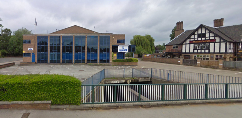
Taken in July 2010 this is another shot of the building that housed the offices of Mansell Construction Services Ltd. with Sherwood Truck and Van occupying the rear of the property. In front can be seen the stone parapet of the bridge that once carried the Derby Road over the Nottingham canal. Dating from the 1790s the stone wall was demolished when Mansell/Sherwood Truck and Van building came down. |
|
|
|
|
|
So now we have a £25 million Advanced Manufacturing Building designed by the architects Bond Bryan which provides a new research facility with state-of-the-art workshops and laboratories for some 400 staff, students and researchers. It was given a design award by RIBA East Midlands in 2018 and is a most welcome addition to the Derby Road. |
This is Lenton Lodge on Derby Road. It formerly served as the gatehouse and main entrance to Wollaton Hall and surrounding park. Over the course of time this particular building has featured on a whole host of different photographs and other images. We have provided a solitary image of it here and offer a separate webpage solely dedicated to this building if you click here. This particular photograph was taken by Robert Howard. |
Having just passed Lenton Lodge, the former Wollaton Park gatehouse, we move on to Wollaton Hall Drive going off on the right of this shot. Located part way along Wollaton Hall Drive is St Mary's Church, Wollaton Park. Designed by T.C. Howitt, and paid for by William Goodacre Player (of Player and Sons' cigarettes) the church was formally consecrated in November 1938. Originally a daughter church of Holy Trinity Church, Lenton, it became a parish church in its own right in 1957. |
|
|
|
|
|
This is the same section of Derby Road as in the previous photograph. There is some uncertainty as to quite when this photograph was taken. It was either in 1913 or in 1914. If it was in 1913 then these are men in a territorial battalion marching out of Nottingham on their way to their summer camp. If it was 1914 then they are heading to the Barracks at Derby having been mobilised following the outbreak of war. |
Here is a shot of a No.45 Nottingham trolley bus heading back into Nottingham having turned on to Derby Road from Middleton Boulevard. The photograph was taken in 1962 shortly before the No.45 trolley bus service was discontinued and replaced by motorbuses. |
This is much the same position on Derby Road as in the previous photograph. This image was taken in 2011. These days it is a much more important bus stop given that off to the right is the main entrance to the Queens Medical Centre. |
|
|
||
|
A view of Derby Road looking eastwards from the road 'island' above the Middleton Boulevard/Clifton Boulevard underpass. Photograph taken in 2019. Off to the right behind the trees are the upper storeys of the Queens Medical Centre. |


From the Railway Bridge to Clifton Boulevard - South side of the road
|
|
|
|
|
The bridge over railway erected in the mid-1880s made life much easier for those travelling through Lenton along the Derby Road but, by the late 1920s, it was considered too narrow to accommodate the level of traffic now passing across it. Consequently it was decided to widen the bridge. As can be seen in this photograph taken on 1 September 1931 work on widening it was proceeding at quite a pace. |
Sixteen days after the previous photograph this one was taken to provide a visual record as to how the work on the new bridgework was progressing. |
The photograph for this picture postcard was taken before the bridge was widened and also before the construction of the Wollaton Park housing estate. This point on Derby Road was the terminus for the trams until an extra quarter of mile of tram track was added taking trams up to Lenton Lodge. This additional bit of track was brought into use in April 1927. |
|
|
|
|
|
In this view of the tram terminus the photographer has walked further along Derby Road in order to include the houses on the right. Given the strange halo effect around some of the figures it looks as though they were added at a later stage. |
One of the houses seen in the previous photograph is also visible in this 2021 shot of Derby Road. It is the property just behind the large tree. Slightly surprisingly the tree had yet to make its appearance in the previous photograph. |
Given the presence of tramlines on this section of Derby Road this photograph must have been taken after April 1927 and before trolleybuses took over from the trams in October 1931. Again it is quite striking that there are, as yet, no trees planted along the side of the road. |
|
|
|
|
|
Part of the same stretch of Derby Road as in the previous photograph but this 2021 shot clearly comes with trees. |
After the row of shops on the other side of Derby Road was demolished this parade of shops was erected at No.357 Derby Road. Take in 2010 this photograph was featured in Lenton Times No.29. The occupants of the various retail units at that time were: Chip Box (present since 2003); Taylor's Food and Drink (since 2004); P.D. Rees Ophthalmic Opticians (since 1983); Silver Scissors (since 1972); Amigo's Pick-a-Pizza (since the early 1980s); Lloyds TSB Bank (since 1975). |
This photograph appeared in the Nottingham Evening Post 1st February 1977 and shows a Barton bus which earlier that day had ended up in the River Leen having careered through the parapet of the bridge. |
|
|
|
|
|
This is the bridge wall, subsequently rebuilt that the Barton's bus had crashed through in the previous photograph. On the opposite side of Derby Road the head offices of Mansell Construction Ltd are also visible. Photograph taken in 2005. |
This 2001 shot shows some intrepid individual perched on the concrete dividing wall in the middle of the river. Although he is clearly taking advantage of the summer sun what may not be totally apparent is that he is actually an angler intent on catching fish. |
These were originally a set of 'single' storey shop units erected in the late 1920s. In 1948 the 'second' storey was added. Officially the block of shops is known as Pollard Court but most locals just call them the Hillside shops. |
|
|
|
|
|
Taken in 1949 this is Pollard Court just after the 'second' storey had been added. The Hillside Post Office - now [2021] Subway, is obscured by the presence of the Be-Ro lorry. The wall the mother and child are walking past is part of the canal bridge. |
Passengers descending at Hillside from a Derby Road trolleybus in 1932. The trolleybus's service number is '8'. In later years it would be altered to No.45. |
In this 1967 shot of Derby Road we have part of the canal bridge parapet on the left and beyond it the junction with Hill Side. It is interesting to note the sign drawing attention to the Travellers Rest public house located over on Spring Close. Given that all the domestic properties in that area would already have been demolished the landlord of the pub would clearly have been very keen to attract new customers to his hostelry. |
|
|
|
|
|
This is Lyndale House, the property located at the corner of Hill Side and Derby Road. In recent years the building has been much extended and is now student apartments. A little of the history of this house is to be found in an article in The Lenton Listener - see below. |
Here is the Derby Road entrance to the John and Eliza Jelley Homes - a set of almshouses that John Jelley requested in his will should be built after his death in 1914. They were subsequently constructed in two stages from 1923 to 1926. There is a detailed article about John and Eliza Jelley and their memorial homes in Lenton Times No.36. |
A portion of the Jelley Homes viewed from Derby Road in June 1987 when the hedge was not quite so dense as it is today [2021]. |
|
|
|
|
|
An early twentieth century picture postcard of Derby Road when traffic was not quite the problem it is today. The postcard is captioned Adams Hill - a name which was given to this stretch of Derby Road when Thomas Adams lived at Lenton Firs in the mid-nineteenth century. Nowadays the use of the name 'Adams Hill' is restricted to those properties on Derby Road beyond Middleton Boulevard. Given the bend in the road and the fairly level road surface we believe this was taken where the main entrance to the Queens Medical Centre is now to be found. |
The same section of Derby Road as in the picture postcard taken in 2017. The entrance to the Queens Medical Centre is via the slip road going off to the left. |
The view looking northwards from the tower block on the University campus. On the left of this photograph taken in 1965 is the junction of Derby Road with Clifton and Middleton Boulevards. The main means of controlling the flow of traffic appears to be a small road island - all very different from what happens today |
|
|
||
|
A 2011 view of the junction with Clifton Boulevard, which is off to the left. Now that the vegetation planted on the banks of the underpass has now grown to maturity it looks quite a sylvan spot. Admittedly when traffic is negotiating its way through this junction you don't tend to look at the trees. |


From the Boulevards to Woodside Road and Wollaton Vale
|
|
|
|
|
Moving along Derby Road towards Beeston this 2021 photograph reveals the north-east entrance to the university courtesy of this slip road off to the left. The properties built inside the old boundary wall of Wollaton Park are off to the right and are accessed by their own service road - now referred to on modern-day maps as 'Adams Hill.' |
Here is the view looking along 'Adams Hill' from its junction with Middleton Boulevard. Clearly the road is only accessible by pedestrians and cyclists at this point - whether that was always the case is unclear. |
This lodge house originally belonged to Lenton Firs and was built in 1861 when extensions were also being carried out to the main house. See June Ingleby's reminiscences of living in Lenton Firs Lodge. |
|
|
|
|
|
This is a 2016 photograph of the access point on Derby Road provided for those properties erected inside the original boundary of Wollaton Park. As stated before the service road to these properties is now what is known as 'Adams Hill.' |
This building originally served as the lodge for Lenton Hall. In the late 1920s the Hall was given to the University by Sir Jesse Boot and the property converted into a men's hall of residence. At one time the lodge itself was also used to house students. This photograph was taken in the early 1990s when the property was just about to undergo refurbishment. |
Taken by Gurjeet Nanrah on 8 February 2019 emergency tree work is taking place on one of the trees on the Adams Hill section of Derby Road which was hanging precariously over the Derby Road. Off to the right of the photograph are the newly built studios belonging to the Architecture Department of Nottingham University. |
|
|
|
|
|
This is the second and smaller gatehouse, known as Beeston Lodge, which provides access to Wollaton Park. Along with the bus and two cars a horse and cart is evidently making its way along the road - not something you are likely to see these days. |
On the opposite side of Derby Road to Beeston Lodge is this cut through providing pedestrian access to the University campus. Nowadays Beeston Lane forms part of the internal roadways within the campus but originally it would have joined Derby Road more or less at this point. At this junction with Derby Road a toll house and gate were positioned to collect the tolls for those wanting to access the turnpike road running through Beeston and out to Sawley. When the parliamentary act lapsed in 1870 the tollhouse would be demolished. Sadly there are no extant illustrations showing what it used to look like. |
We don't have a date for this photograph but from the style of dress of the woman passing by we must be back in Victorian times. One of the doors has been left open but we presume there are a set of metal railings set in place behind it. These would stop any animals in the park grounds wandering on to Derby Road. |
|
|
|
|
|
An early twentieth century shot of Beeston Lodge taken by Arthur William Bird. Mr Bird (1871-1963) was a keen amateur photographer and many of his Nottingham photographs have subsequently been lodged with the Local Studies Library in Angel Row. The man in the photograph is identified as Tom Poole. |
A picture postcard focusing on the stretch of Derby Road with Beeston Lodge on the left. From the smoke issuing from one of the chimneys it was clearly still in use as a domicile. Not something you can say about the property these days. |
A 2021 shot of the same section of Derby Road as in the previous photograph. The traffic lights having turned red and Paul Bexon risked standing in the road to get this image. Note the windows in the lodge are now all permanently boarded up. |
|
|
|
|
|
Not only was this stretch of the Derby Road popular with local photographers it also attracted the odd painter. It is, however, difficult to believe that the road ever looked quite as rustic as depicted in this painting. We don't know anything about the painting's provenance - so let us know if you can tell us more about it. |
Taken by Matt Greenaway on 31 December 2022 this photograph shows a branch from one of the trees inside Wollaton Park had fallen across a section of Derby Road just to the west of Beeston Lodge. |
At the end of this private drive is a property called Lenton Abbey. Although it is owned by the University it is not part of the campus. Construction on the house began in 1798 and was completed by 1800. Attached to the property was a farm and much of its lands were acquired by Nottingham Corporation in 1925 and subsequently used for the Lenton Abbey council estate. The Corporation did not want to buy the house and so it remained a private property finally being acquired by the University in 1969. The building is now divided up into several apartments. |
|
|
|
|
|
An early twentieth century photograph of the lodge on Derby Road that formed part of the Lenton Abbey estate. This photograph featured in an article to be found in Lenton Times No.30. |
Lenton Abbey lodge as it looks today seen on the left of this 2020 photograph. On the right is the junction with Charles Avenue. |
Taken in 2014 by Alan Murray-Rust this is St Barnabas Church, Lenton Abbey. Designed by local architect T Cecil Howitt to serve the residents of the recently developed Lenton Abbey council estate. St Barnabas was opened in June 1938, originally as a chapel of ease to Holy Trinity, Lenton, but became a parish in its own right in 1955. |
|
|
|
|
|
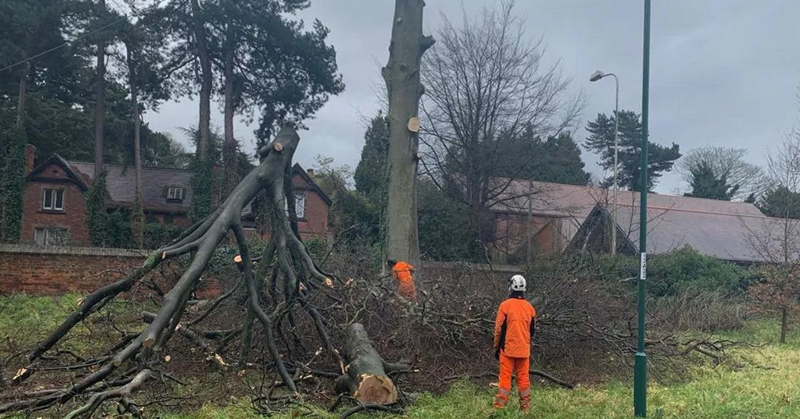
A photograph taken a policeman based at Radford Road Police Station on 20 September 2020 shows one of the trees lining the edge of Lenton Abbey recreation ground has collapsed on to Derby Road. This meant that all traffic trying to use this section of Derby Road had to find an alternative route for several hours until the tree could be cut up and removed by members of the Parks Department. |
With Woodside Road off to the right we reach the end of our allotted section of the Derby Road. In the photograph taken in 2019 we see the entrance to Lenton Abbey Recreation Ground. The lodge is somewhat older than the recreation ground dating from c.1860 and acquired Grade 2 listing in 1995. |


Articles from 'The Lenton Listener' Magazine
The Derby Road Story - Issue 15 - November to December 1981
Derby Road - The Ghost With Unlikely Associations! - Issue 22 - January to February 1983
Lenton Firs Farm - The Farmer's Tale - Issue 34 - May to June 1985
The Three Wheatsheaves - Issue 38 - April to May 1987
Why The Three Wheatsheaves? - Issue 38 - April to May 1987
The Donkey Pub - Issue 38 - April to May 1987
Mick and Linda Sisson - Issue 38 - April to May 1987
Lenton United Cricket Club - Cricket Lovely Cricket - Issue 47 - August to September 1987
Dorothy Thomas - Hillside, Derby Road in the 1940s
My family lived on Averton Square in the Wollaton Park estate. Every so often my mother would send me to the shops at Hillside. So the quickest route would be to go along Orston Drive and then on to Charnock Avenue. After that it would be along the 'Stumps' the name we gave to the cut through to Derby Road. I was all right until I had to pass the men's urinal when I was always slightly worried that someone might be lurking there and jump out at me - but they never did!
Located at the corner of the block of shops that stretched down as far as the Rose and Crown was the Leyland garage. When the big doors were open you caught a view of the office off to one side, where one of our neighbours, Wilfred Ison, used to work. After the garage came the first of the row of small shops - a sweet shop run by a very pleasant lady called Miss McGlade. Those were the days when sweets came in big jars and your selections were weighed out for you and given to you in paper bags. With my threepence weekly pocket money plus the relevant ration book to hand it might take me ages to decide how best to spend it. Next to the sweet shop was a hairdresser. In that particular establishment each customer was attended to in their own curtained-off cubicle. After Walter's greengrocer's shop came the Co-op - which was double the size of the adjoining shops. Here Tom Payne, who lived at Lenton Abbey, was in charge of the section that dispensed the likes of bacon, cheese and butter. The bacon was sliced while you waited; the cheese came in big 'wheels' and smaller pieces were cut off it using a piece of wire to slice through them; the butter was wrapped for you on the counter in greaseproof paper - there wasn't that much pre-packaging in those days. The other half of the shop was given over to various other grocery products and you would usually be served by the manager, Mr Marlow. After he retired Mr Kitchen took over. The Co-op shop also had a big tortoiseshell long-haired cat called Fluff. I suppose he was kept there to deal with any mice that might be tempted to try their luck in the Co-op storeroom and front of shop. I didn't really go into the shop on the other side of the Co-op but I do recall that the young couple who ran it had a little girl called Penelope.
Back at the Leyland garage there were several more shops that fronted on to a short stretch of roadway that really didn't go anywhere. After a jeweller's shop and the Oporto wine shop was the fish and chip shop run by Arthur and Ethel Crafts, whose own home was on Hawton Crescent. My regular order was for three pennyworth of chips and a sixpenny cod and if you were lucky Mrs Crafts might put some crispy bits in as well. They were all put into greaseproof paper and then wrapped in newspaper for the journey back home. My brother, Roland, subsequently used to help out at the shop. My mother would complain about his clothes smelling after he'd been working behind the counter but she never grumbled about the bottle of peanut oil that Roland brought home, courtesy of Mrs Crafts.
On the other side of the Derby Road was the Hillside Post Office and a flower shop, as I remember, but I didn't have much occasion to go across to them.
Peter Cartwright
Dick Cartwright was my grandfather who lived at No.1. The Butt Houses, on Derby Road. He used to be the groundsman for Lenton United Cricket Club and I would spent all my school holidays during the Second World War with him at No.1.
David Clarke
David Clarke sheds further light on this row of properties: This block of three-storey early Victorian properties are of a style that is common in this area. Typically they now have garage openings at street level. Somewhat confusingly this block of properties has two names - Brunel Terrace and Derby Terrace. Nearby there is Wellington Terrace and Western Terrace. The building abutting on to Arundel Street also features on a photograph on the Picture the Past website where it is described as 'formerly Great Central Railway Contractor's Office, 1896. Derby Terrace is to the right.' The 1896 date certainly corresponds to the development of the Great Central Railway, though the building must be much older than 1896. There is a crest carved in the stonework (unreadable from ground level) - is it GCR or GWR? Something else worthy of note is the raised situation of the front doors of these properties (on both sides of Derby Road and also evident on nearby Ilkeston Road), which gives an indication of the degree to which the road level has been reduced over the years.
Bill Pugsley, Huntington, New York, USA

With reference to your photos of Derby Road up near Canning Circus I used to live in a property on Hermon Street which was situated at the side of the Drill Hall. This area was a hive of activity during the World War 2. It's now clearly much changed. The shop at the corner of Hermon Street was a dairy and the one you can see in the current photograph by the dustbins was a fruit & vegetable run by Mrs. Woolard. Then there were the wide stone steps leading up to Park Hill which served as a cut-through to Ilkeston Road. The shop on the other side of the steps used to be a newsagents (Meyers) and they had an aviary full of birds positioned between the two bay windows. It was later a bread and sweets shop owned by Mr Fisher who also had the bake house on Park Hill. My father worked for him occasionally and I helped with deliveries on weekends and holidays. Next to them was Robson's the chemists then after Alton's building at the corner of Elliot Street was a kosher butcher's run by Jack Scholl. Our family doctor was Dr. Tannian, whose surgery was situated at the corner of Wellington Square and Derby Road. So many memories!
June Ingleby - Australia
I was born in Mansfield in 1928. When I was about 17 we moved to Nottingham where my father became the caretaker at Lenton Firs. At that time it was a Hall of Residence for female students. We lived in the gatehouse just off Derby Road. Not the main drive I might add but the second one. I have certain 'not so happy' memories of our stay there, as we had no bathroom and were back to the days of the bathtub on the kitchen floor.....or a strip wash in the laundry. We were always promised a bathroom but it failed to appear while we were there. Eventually we moved to Aspley and acquired a bathroom and all mod-cons. The gardens at Lenton Firs were quite beautiful and we did enjoy those. On top of the stables was a clock tower and my father fixed this clock which hadn't worked for many years. In 1951 we migrated to Australia so I don't know what happened to the place after that.
Horace Tomlinson - From The Lenton Listener - Issue 36 - October to November 1985

Beside the old lodge gates to Wollaton Hall on Derby Road is the old metal pump in the photograph. For Horace Tomlinson it is a reminder of happy days spent nearby on the canal bank.
When I was a lad of nine or ten, round about the time of the first world war, my pals and I started walking out to the stretch of canal which ran beside the gatehouse from Langley Mill to the Trent. We took our fishing rods, for this point on the canal was always a good spot in which to try and catch roach, perch or eels. As we sat there keeping an eye on our floats bobbing up and down, every so often we would watch a barge coming through the lock just up from the Derby Road bridge. The barges were pulled by a horse walking along the towpath. Often as not the bargee would stop beside the pump and fetch a bucket of water for the horse to drink. He would also give the horse a bag of oats. After resting for about half an hour it would be time to set off again. The horse would have done the journey so often it must have known every step of the way. Usually the barges were carrying coal from the Wollaton Pit, which they took to the London Road depot. Later in the day we might see the horse and barge, now empty, making the return journey. Occasionally we stayed on late in to the evening and then we might see barges coming along carrying a different cargo. We had no difficulty telling what it was, as the smell gave the game away. Up near what is now known as the Raleigh Island was the spot at which all the sewage, collected from households where the outside toilet lacked any plumbing, was loaded into the barges. Quite where the bargees were taking their unpleasant loads I'm not sure - we were never tempted to wander alongside and find out.
Let us know your memories of the Derby Road
Do you have any historical information or other photographs of this area? If so, email us with the details or write to us.