
Beyond Lenton | From Wollaton Road to Derby Road | The old course of the river | From Derby Road to the Nottingham Canal | From the Nottingham Canal to the River Trent | Lenton Listener Article | Memories | Map
|
|
|
|
|
The river Leen passing through Radford in the very early 1900s. Quite where the equivalent stretch of the river is today is anyone's guess. |
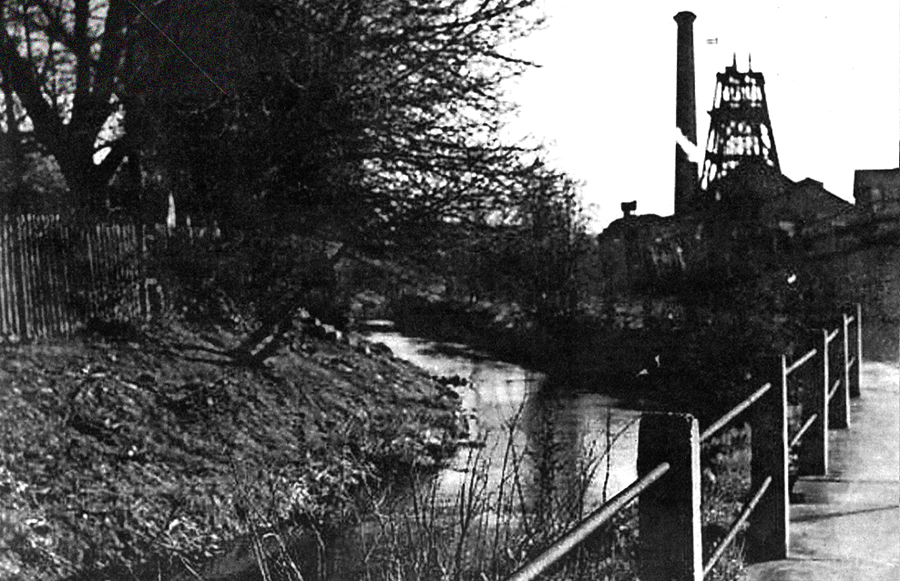
Looking southwards in 1972 is the River Leen as it passes Radford Colliery. Radford Colliery was operational from 1898 to 1964 and prior to nationalisation was owned by Wollaton Collieries Ltd. |

From Wollaton Road, Radford to Derby Road, Lenton
|
|
|
|
|
Immediately ahead of us in this photograph, taken of Wollaton Road just after the junction with Faraday Road and St Peter's Street, the road rises quite steeply in order to get over the railway line. Just before the railway bridge the road also passes over the river Leen. The parapet of the bridge for the Leen, constructed of red brickwork, is visible in the centre of the photograph. |
In this photograph we are now looking over the parapet of the bridge. To some extent the view is obscured by the large pipe but below it and beyond it can clearly be seen the waters of the Leen. Just out of camera shot, the Leen will enter a culvert which runs alongside the railway line just at the back of the new student residential complex and the Derwent Housing Association s properties on Faraday Road. The river makes a brief reappearance near the southern end of the Housing Association s properties before being directed under the railway to emerge once more on the western side of the railway line. |
The river Leen, here takes centre stage. The railway line is off to the right and on the left is the new lake created as an additional feature for the University's Jubilee Campus centred on Triumph Road. There is a small water wheel positioned in the waters of the Leen perhaps someone can tell us if this wheel is there as merely an ornament or whether it has a more practical purpose? |
|
|
|
|
|
This photograph shows the view looking south with the student housing complex recently built on Radmarsh Road on the left. Taken in 2008 the University has yet to have erected the footbridge over the Leen which provides pedestrian access between Radmarsh Road and the Jubilee Campus. |
A 2011 shot of the lake and the river Leen with some of the Jubilee campus building visible in the distance. |
A similar shot just moving a few yards further south but now the new footbridge over the Leen hoves into view. |
|
|
|
|
|
The view of the Leen looking southwards when standing on the footbridge. In the distance the waters of the Leen will be about to enter a culvert that will take the river under the commercial buildings situated at the southern end of Triumph Road. |
Once the river has passed under Triumph Road it becomes visible once more. Although this shot of the Leen was taken in the early 1970s the view itself has changed relatively little in the ensuing years. The property on the left known as Fanum House which used to house the regional offices of the Automobile Association is now occupied by Nottingham Emergency Medical Services. |
The stretch of open river shown in the previous photograph ends at the point where you see the railings and once more the river is sent into a culvert. The shot was taken while standing in Mansell's carpark. |
|
|
|
|
|
No river is evident at this point, as it is culverted and passing beneath the carparking area shown in the foreground. But, with the Rose and Crown pub clearly visible on the right, if you look into the middle distance on the left, you can see the builder's skip and the trees shown in the previous photograph. Before the extensive works carried out on the Leen in the 1960s the course of the river at this point would have gone slightly further to the west before passing under Derby Road. The mill that once used the waters of the Leen to grind corn would have been situated where the car park for Sherwood Truck and Van is now located. |
The waters of the Leen become visible once more just as they pass under the Derby Road. The Hillside shops on the southern side of Derby Road can be seen in the middle distance. |


The old course of the the river from Derby Road to the Nottingham Canal
|
|
|
|
|
This shows part of the bridgework that used to carry the Derby Road over the river Leen in the early twentieth century. The old bridge was much wider than the current bridgework as the Leen on its approach to the Derby Road was allowed to flow in a much wider channel. |
Until the early 1960s the river Leen ran more or less parallel to the Nottingham canal until Abbey Street after which it turned and headed eastwards and ran parallel with the canal until it got as far as the railway line when it was directed into the canal. This shot, viewed from the canal bank, shows the point where the Leen enters the canal. |


From Derby Road to the Nottingham Canal
|
|
|
|
|
Having passed under the Derby Road the river is visible for a short while before entering a further culvert that takes it under the carpark of what we still know [in 2011] as the Hillside Club although the club has now closed and the property has been put up for sale. |
The same section of the Leen as in the previous photograph but looking southwards. The photograph was taken mid-afternoon on Thursday 14 November 2019 after a period of very heavy rain. Had the Leen risen another six inches the area would probably have suffered major flooding - but it didn't! |
As stated in the section above, until the 1960s the river Leen used to run in a course located to the east of this photograph. Before then any photograph taken at this particular location [Hillside] would have shown a portion of the long-abandoned canal. In other parts of the city the canal was simply filled in but the stretch between the Derby Road and the Beeston Cut was commandeered for the river Leen. This particular photograph shows the river as it emerges from the culvert. |
|
|
|
|
|
Taken from the road bridge providing access to the Queens Medical Centre from Leengate, this is the view of the river looking back towards the Derby Road. Until quite recently the hospital s multi-storey carpark would have been just visible on the extreme left of the photograph but structural faults in the building s construction has meant that it has now had to be demolished. Its departure may mean added carparking problems for those using the hospital but ensures that this particular view can now look even more countrified than before. |
Looking across the river from Hillside. Over on the other side is the western end of the housing complex that now occupies Bayley s old tannery buildings which front on to Leengate. |
The view looking south from the Leengate road bridge. The embankment would appear to have become a popular spot with ducks. The scene is likely to change somewhat once work begins on the new tramline when another new bridge will need to be constructed to take the trams over the river at this point. |
|
|
|
|
|
John Hibbitt took this shot in April 2014 from a waiting room window at the Queens Medical Centre. The river Leen can be seen in the bottom left corner but John's interest is clearly on the bridge for the tram spanning the river which is nearing completion. |
If you look at the middle distance of the previous photograph you will see the course of the river Leen begins to bend to the left. That bend in the river is the same as the one that can be seen in this 1950s photograph of the canal as we approach Abbey Street. |
Alongside the old Abbey Street bridge a further bridge has been constructed principally to ensure that cyclists at this point using the cycle path don t have share the narrow pavement with pedestrians. This photograph shows the cycle path bridge in the foreground and the river Leen looking back to the hospital complex. The new day treatment centre is housed in the blue building visible on the left of the photograph. |
|
|
|
|
|
In the days when the canal passed under the Abbey Street bridge there was a set of locks at this point. These were taken out as no longer needed for the river and no sign remains to indicate they were once here. This photograph shows the cycle path bridge shown in the previous photograph and the Johnson Arms built by Frank Johnson about 1912. He was replacing a much older hostelry situated here which was known as the Abbey Tavern. |
A view of the river looking southwards from the Abbey Street bridge - the side of the Johnson Arms is just visible on the left while on the right are the backs of the houses on Cloister Street. |
This photograph was also taken from the Abbey Street bridge and shows the river Leen swollen with all the water that gets directed into it after heavy rain. You don t normally get quite so much water as is shown in this particular photograph. Had the river risen any higher the houses on Cloister Street would almost certainly have been inundated with floodwater. |


From the Nottingham Canal to the River Trent
|
|
|
|
|
The section of canal visible in the middle distance, leading up to the Abbey Street bridge, is going to be used for the course of the Leen. In the early 1960s these workmen are constructing the siphon that will eventually allow the waters of the Leen to pass under the canal and on to the Trent along a completely new route for this section of the Leen. |
Once the waters of the Leen has passed under the canal, as it can be seen in this photograph, the river heads towards the commercial and industrial premises lining Willow Road. After this it will re-enter a culvert in order to get underneath the main Nottingham to Derby railway line and Lenton Lane. |
Once under Lenton Lane this is the river as it flows past the now realigned Birdcage Walk, the footpath that connects Lenton Lane with the Meadows and the River Trent. Over on the right is one of the buildings making up the Queen s Drive Industrial Estate. |
|
|
|
|
|
If this shot had been taken in the 1960s when the new course of the Leen was first constructed the buildings in the distance would have been those belonging to the Royal Ordnance Factory. No trace of that building now remains and instead we have a business park. |
For a portion of this route you can get off the official pathway and continue to walk alongside the river. |
The line of poplars clearly seen in this shot of the Leen must have been around for quite some time. They must have been passed by anyone using this pathway which used to provide a convenient route for anyone wishing to get to the Ordnance factory from Radford and Lenton while also being used by some of Lenton pupils who gained a place at Mundella Grammar School. |
|
|
|
|
|
In this shot we have gone past the line of poplars and are looking back towards Lenton. |
There is obviously a good reason why the sides of the river needed to be constructed in this fashion but quite what it is unclear to us - any suggestions? |
For this particular shot we have moved a bit further downstream and are looking back up the river. The metal structure in the middle is part of a ladder that enables maintenance workers to get down to the water level. |
|
|
|
|
|
The last part of the Leen s journey before finally joining up with the River Trent is all via a culvert. The culvert passes under the land currently occupied by Wickes carpark. This shot is taken from Riverside Way and the actual location of the culvert is clearly defined in the surface of road just in front of these low railings. |
Across on the other side of Riverside Way is a sign indicating that we have reached the point at which the Leen enters the Trent. |
For these last two photographs we have crossed Riverside Way and in this photograph are looking up river with Wilford Church just visible on the other side of the river. |
|
|
||
|
Swivelling round to face down river we can see in far distance the Wilford footbridge. |


Article from 'The Lenton Listener' Magazine
The River Leen and Lenton - Issue 50 - March to April 1988
Let us know your memories of the River Leen
Do you have any historical information or other photographs of this area? If so, email us with the details or write to us.