
Castle Lock to Lenton Chain | George Cartwright - Boat Builder | From Lenton Chain Northwards along the Nottingham Canal | From Lenton Chain Westwards along the Beeston Cut | Memories | Map
|
|
|
|
|
The footbridge near Castle Lock that carries pedestrians across the canal overflow. In the 1880s the River Leen was redirected into the canal at Lenton. The excess river water then left the canal at this point and flowed across The Meadows and then into the Trent. This arrangement prevailed until the 1960s when a new course for the River Leen from Lenton to the Trent was constructed. Also see The River Leen and Lenton & Birth of the Boulevard |
The rear of New Castle House shot from the Nottingham Canal. See photographs of the front of the building on Castle Boulevard. |
This undated picture postcard shows a group of anglers fishing in the Nottingham Canal with Nottingham Castle clearly visible in the background. |
|
|
|
|
|
The same view as in the previous photograph but taken in 2006. The party of track-suited men walking along the towpath towards Nottingham are the first team squad of Millwall F.C. who had been staying at the hotel on the Castle Marina site, prior to going on to their match at Chesterfield. This pre-match walk didn't do them much good as Chesterfield won the game 5-1 (12 August 2006). |
In the 1950s and 60s George Cartwright and his family lived in the house boat shown here moored on the canal on the stretch running alongside Castle Boulevard. On the patch of land between the canal and Castle Boulevard he ran a boat building business. For three further photographs relating to the Cartwright business see below. |
A view of the Nottingham Canal with the properties situated at the ends of Marcus Street, Chippendale Street, Cecil Street and in the far distance Charlton Street visible on the far side of the canal. Photograph taken in 1973. |
|
|
|
|
|
Built by a local Housing Association at the same time as Barratts were erecting their Castle Gardens complex, this row of properties offers its occupants not only a view of the canal but also the marina constructed alongside it. |
This picture postcard No. 180a in the 'Clumber' series shows a view of the Nottingham Canal with the railway bridge in the middle distance. The end properties of Petersham Street (now all demolished) can be seen on the right of the postcard. |
A 2007 view of the canal showing the same railway bridge as in the picture postcard shown on the left. The properties on Petersham Street have now been replaced by Petersham Mews, with some of the canal side properties just visible on the right. |
|
|
|
|
|
Taken at the same time as the previous photograph we focus more on the railway bridge itself with just a hint of the Petersham Mews development over on the right. |
The bridge carries the Nottingham to Mansfield railway line over the canal. This 1987 photograph shows work taking place on the canal bank. This portion of canal bank was the point at which the River Leen was redirected into the canal in the 1880s. |
The stretch of canal between the railway bridge and the Gregory Street road bridge. On the right are the premises of Mellors and Kirk, the fine art auctioneers. The previous occupants of the buildings were British Telecom. |
|
|
|
|
|
Another in the Clumber series of picture postcards. This one shows the section of canal with Clayton's Bridge in the middle distance. This bridge linked Gregory Street with Trent Lane (now renamed Lenton Lane). If you compare this picture with the other 'Clumber' postcard included in this sequence you will notice that the same 'girl' is featured in both shots - suggesting they were both probably taken on the same day. |
The old road bridge was replaced in the 1950s with the one shown in this photograph. On the left are part of the canalside properties that now make up Clayton's Drive. |
Moving slightly further down the towpath than in the last photograph all the properties making up Clayton's Drive are visible plus a couple of the boats moored alongside Trevethick's boatyard. |
|
|
|
|
|
A painting of Lenton Boatyard by Thomas Cooper Moore dated c1850. Apart from showing the boatyard the foreground, on the right of the picture in the background is the building that would later house the Midland Orphanage for Girls. |
This image of the Lenton boatyard is taken from an early picture postcard. However it is unclear quite when the photograph itself was actually taken. |
As the previous images make clear the boat yard, as seen in this 2004 photograph, has been a long-established feature of this stretch of the canal. For most of the twentieth century it was operated by the Trevethick family. However, although the business is still known as Trevethick's, it is now run by Colin Rawlson. |
|
|
|
|
|
The buildings which now make up Trevethick's boatyard are clearly of more recent origin than those shown in the previous two images but, apart from a new lick of paint, have probably not changed very much in the past fifty years or so. |
This photograph focuses on the dry dock at Trevethick's boatyard with two boats undergoing repair or being repainted. |
A 1989 photograph showing the canal side properties which formed part of The Friary housing development built by A.F. Hunt (Builders) Ltd. the previous year. |
|
|
|
|
|
The same stretch of canal as in the previous shot but taken fifteen years later. |
This Winter 1984 photograph shows the Nottingham Canal as we approach the end of Cloister Street (the location of the Lenton Chain). The B&B Foundry can be seen in the centre and the Dunkirk Fire Station tower is in the distance. |
B&B Foundry was run by J. Barber & E. Brockway. After they vacated the building it was demolished and the current student accommodation called Cloister House was constructed. |
|
|
|
|
|
This shot, taken in the early 1900s, shows the junction of the Nottingham Canal with the Beeston Cut. The footbridge provided pedestrian access between the two sections of tow path. In the middle distance are the Cloister Street properties which backed on to the canal and to the right would have been the grounds of Nazareth House. |
This is the Lenton Chain where the Beeston Cut, just visible on the left, joins the Nottingham Canal, which can be seen heading northwards towards Abbey Street and beyond.This portion of the canal was subsequently used to house the rerouted River Leen and this 1960s photograph shows work progressing on the siphon which will direct the waters of the River Leen under the canal and into a completely new stretch of river bed. |
The boat in this 1989 photograph is passing directly over the siphon which now takes the River Leen under the canal. |


George Cartwright - Boat Builder
|
|
|
|
|
In the 1950s and 60s George E. Cartwright built cabin cruisers on a plot of land alongside the canal on Castle Boulevard. The first of these three photographs, all supplied by his daughter Sue Hutchings, features a finished boat on display at the boat yard. The second shows George Cartwright at work and the third in the sequence is a completed boat about to be launched into the canal. In the last mentioned photograph the Cartwright's house boat can be seen to the left - at one time this would have been the family home for George, his wife and their four children. |
||


From Lenton Chain Northwards along the Nottingham Canal
|
|
|
|
|
The stretch of canal leading up from Lenton Chain to the Abbey Street lock. The lock is just visible beyond the Abbey Street road bridge. The building on the right is the Abbey Tavern which was later replaced by the Johnson Arms. |
A picture postcard showing the Abbey Tavern from further along the canal, having just gone under the Abbey Street bridge. In front of the bridge is Lock No.3. Postcard published about 1910. |
Same view as the picture postcard but as it was taken in the 1950s the canal bridge is now different and the pub is, of course, The Johnson Arms named after Frank Johnson, the man who had it built in 1912. |
|
|
|
|
|
By the 1950s when this photograph was taken the canal had formerly been abandoned and was now badly silted up. This section of canal lies between Abbey Street and Leen Gate. |
Taken in the late 1890s this photograph shows Hillside with the Nottingham Canal lying next to it. This portion of the canal was eventually filled in during the 1960s. The photograph shows the maltings featured in Frank Barnes' Lenton Times article, which is reproduced in full in our online edition of Issue 3. |
This photograph shows the Nottingham canal as it is about to go under the Derby Road with Lenton Lodge, the gatehouse to Wollaton Hall in the background. The image first appeared in a book called 'Amos Deer' written by the Reverend Henry Roe which was published in 1902. |
|
|
|
|
|
This 1901 photograph shows a portion of the canal lock beside Derby Road with Lenton Lodge, the gatehouse to Wollaton Hall, in the background. The photograph was taken by Arthur William Bird. |
Half way between Derby Road and Wollaton Road was the No. 5 Lock shown in this photograph. On the far side of the canal is the boundary wall of Wollaton Park. No date is given for the photograph. |
The top end of No.5 Lock with the gasometers of Radford Gasworks visible in the far distance. On the right are some of the properties associated with Triumph Road. We have no date for this photograph, originally taken by Mrs Ada Marriott, so if anyone can tell us when the 'caravan park' came on the scene we may be able to hazard a guess. |
|
|
||
|
Taken in the early twentieth century by Arthur William Bird this shot shows the Nottingham canal as we approach the Wollaton Road. The bridge over the canal can just be seen on the left of the photograph. The site today would now form the north western corner of the Jubilee Campus. |


From Lenton Chain Westwards along the Beeston Cut
|
|
|
|
|
This is the stretch of canal between the end of Cloister Street and Warwick Street taken in May 2005, with some of the properties on the latter street just visible in the background. |
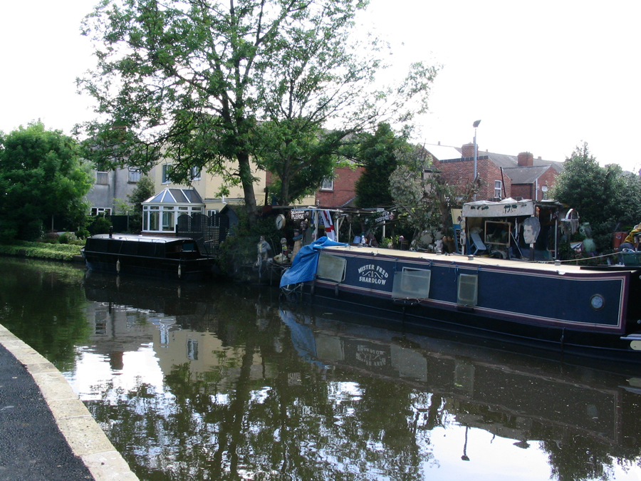
There are a number of permanent moorings at this point and some of the owners choose to personalise them in their own unique fashion. |
The same stretch of canal also taken in May 2005 but this time the photograph shows the view looking back towards Cloister Street. |
|
|
|
|
|
The same stretch of canal but just a little further westward with the gable end of one of the two Warwick Street canal side properties just visible on the left of this 1989 photograph. |
The second of the canal side properties on Warwick Street is this one known as Warwick House. |
With access to it from Dunkirk Road this housing development was erected alongside the canal in the late 1980s. |
|
|
|
|
|
The section of canal as we approach Clifton Boulevard. The bridge which carries the road over both the canal and the railway line is just visible in the far distance in this 2004 photograph. |
This is the stretch of canal just beyond Clifton Boulevard looking eastwards. The bridge which carries the Nottingham to Derby railway line across the canal is visible in the far distance. |
Much the same view as in the previous photograph but a slightly higher elevation has been achieved by taking it from the canal bridge. |
|
|
|
|
|
This bridge used to provide vehicular access from Gibbons Street in Dunkirk to Chain Lane. The latter road no longer exists and instead it provides pedestrians with the means of getting from Dunkirk to the Showcase Cinema complex. The bridge was rebuilt in the 1980s to allow boats to pass through it more easily. |
The view from the bridge in May 2004 but this time looking westwards towards Beeston. |
The same stretch of canal in 1989 but looking back towards Lenton. Most of this part of Dunkirk has been given over to an industrial estate but the short terrace of houses on Gibbons Street and backing on to the canal can be seen in this photograph. |
|
|
||
|
Among the businesses operating in the Dunkirk Industrial Estate are several vehicle salvage yards. The canal bank of the Beeston Cut provided a convenient area for 'parking' recent purchases by one of the proprietors back in 1989. |


Let us know your memories of the Nottingham Canal
Do you have any historical information or other photographs of this area? If so, email us with the details or write to us.